

Adverse weather in the coming days may affect the sensitivity of the monitoring network.
Updated 4 February at 13:45 UTC
Weather conditions in the coming days could affect the monitoring capabilities
Magma accumulation beneath Svartsengi and the associated land uplift continues
The period of increased risk of a volcanic eruption risk may last up to a month or longer
Seismic activity remains low
Hazard assessment remains unchanged
The weather forecast for the coming days indicates a series of low-pressure systems moving across the country, bringing strong southwesterly and southerly winds along with precipitation. These weather conditions may affect measurement capabilities, particularly in terms of visibility and the sensitivity of seismic and real-time GPS measurements. The Icelandic Meteorological Office will continue to monitor the situation closely, and the public is advised to stay informed about weather warnings and exercise caution when travelling.
Deformation measurements continue to show ongoing land uplift and magma accumulation beneath Svartsengi. As reported last week, the amount of magma accumulating beneath Svartsengi is now approaching the lower threshold, believed to be necessary to trigger the next magma intrusion. If we look at the recent eruptions on the Sundhnúkur crater row, they have occurred anywhere between three days and four weeks after reaching this lower threshold. However, this does not mean that the next event will occur within a month, but rather that experience suggests this as the most likely scenario.

Movements recorded at GPS station HS02 in the Svartsengi area since 11 November, 2023, showing displacement in north, east, and vertical directions (top, middle, bottom). The bottom graph represents land uplift in millimeters, with yesterday's (3 February) measurement marked by a green dot. Red lines indicate the onset of the last seven eruptions (18 December, 2023; 14 January, 8 February, 16 March, 29 May, 22 August, and 20 November, 2024). Blue lines represent magma intrusions that did not result in an eruption (10 November, 2023, and 2 March, 2024).
Seismic activity near the Sundhnúkur crater row has remained low since the last eruption ended on 9 December. Only a few small earthquakes are being recorded daily. However, poor weather conditions and strong winds may affect measurement sensitivity.
The hazard assessment remains unchanged and is valid until February 11.
Updated 31. January at 16:00 UTC
Ground uplift and magma accumulation under Svartsengi continues
The volume of magma accumulating beneath Svartsengi is approaching the volume drop observed during the last event
The likelihood of a new magma intrusion or eruption is increasing
The period of heightened likelihood of an eruption could last up to a month or longer
Seismicity prior to the next eruption might be minimal
Weather conditions in the coming days could affect the monitoring capabilities
Severe weather has affected the entire Reykjanes Peninsula since yesterday. According to the forecasts, weather in the coming days may impact the monitoring and the response time in case of a a magma intrusion or eruption occurs. Strong winds, sleet, and snow could interfere with seismic measurements and reduce the accuracy of GPS monitoring of ground uplift.
The Icelandic Meteorological Office will continue to closely monitor developments, and people are encouraged to pay attention to weather warnings and exercise caution when traveling.
Model calculations are used to estimate the volume of magma which is accumulating beneath Svartsengi. This estimate is not a precise number but rather defines a range with "lower" and "upper" boundary. According to the latest models, the volume of magma under Svartsengi has now reached the lower boundary of the volume loss observed during the last event. Based on past eruptions, these models suggest that magma intrusions or eruptions tend to occur once this lower boundary is reached.
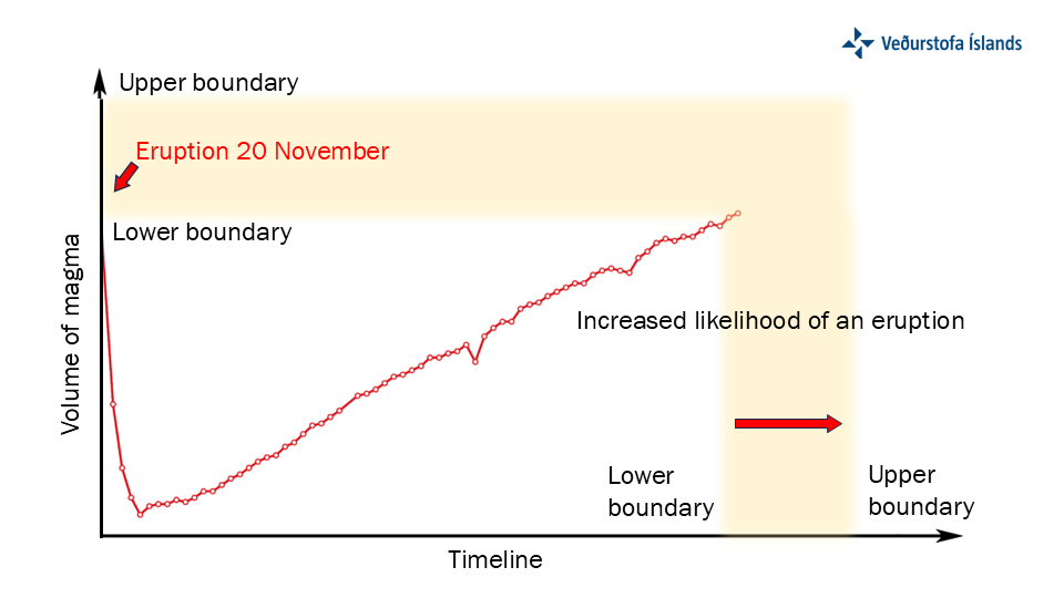
The graph shows model calculations of magma volume accumulating beneath Svartsengi over time. The y-axis represents volume of magma within the magma domain, and the x-axis represents time. Two thresholds are indicated: "lower boundary" and "upper boundary," which signify the range where the likelihood of magma intrusion and eruption increases.
As the lower threshold is reached, the likelihood of an eruption begins to grow. The model is based on ground deformation rates measured with GPS data, which indicate magma accumulation beneath Svartsengi. If the rate of ground uplift slows, indicating a reduction in magma accumulation, it could affect the calculations and alter the timing of the lower and upper boundaries.
Looking to those eruptions that occurred since January 2024, the time between reaching the lower boundary and the onset of an eruption in the Sundhnúks crater row has ranged from a few days to a month. Therefore, the period of increased likelihood for an eruption has different duration between events and may last up to a month or longer.

The graph illustrates the number of days between reaching the lower boundary and the onset of an eruption for six events which occurred in 2024. The y-axis lists eruption dates, while the x-axis shows the number of days elapsed from reaching the lower boundary. Note that the eruption which commenced on May 29 was excluded from this analysis, as it is believed that a system change occurred prior to this event.
Updated 28. January at 17:30 UTC
Ground uplift and magma accumulation under Svartsengi continues
The volume of magma accumulating beneath Svartsengi is approaching the volume drop that occurred during the last event
The likelihood of a new magma intrusion and potentially an eruption is increasing
There is a possibility that seismic activity may not be significant prior to the next eruption
The updated hazard assessment is valid until February 11, barring further developments
Deformation measurements indicate continued ground uplift and magma accumulation beneath Svartsengi. The sequence of events remains similar to those observed before the last eruptions. Modeling calculations show that the volume of magma accumulating beneath Svartsengi is nearing the volume drop that occurred during the last event.
Based on the analysis of previous events, scientists have assessed that once a similar volume of magma has accumulated beneath Svartsengi as during previous eruptions, the likelihood of a new magma intrusion and even an eruption increases.
The Icelandic Meteorological Office has updated the hazard assessment, which is now valid until February 11, barring any changes. It has been decided to raise the hazard level in zones 4 and 6 from “moderate” (yellow) to “considerable” (orange). This change is based on modeling calculations indicating that the volume of magma accumulating beneath Svartsengi is nearing the volume drop that occurred during the last event.
According to the weather forecast, severe weather is expected to occur in the coming days, beginning January 30.throughout the week. A southern storm accompanied by significant warming, rain, and drizzle is forecasted for southern and western parts of the country later this week and into the weekend. Adverse weather could reduce the sensitivity of the monitoring network, potentially delaying response times to an eruption.

(Image of the updated hazard map)
Seismic activity in the Sundhnúkar crater row has been increasing gradually since the end of the eruption on December 9, 2024, but overall it remains low. Developments over the past year suggest that seismic activity prior to magma intrusions has been decreasing with each event. Consequently, there is a possibility that seismic activity may not be significant prior to the next eruption.
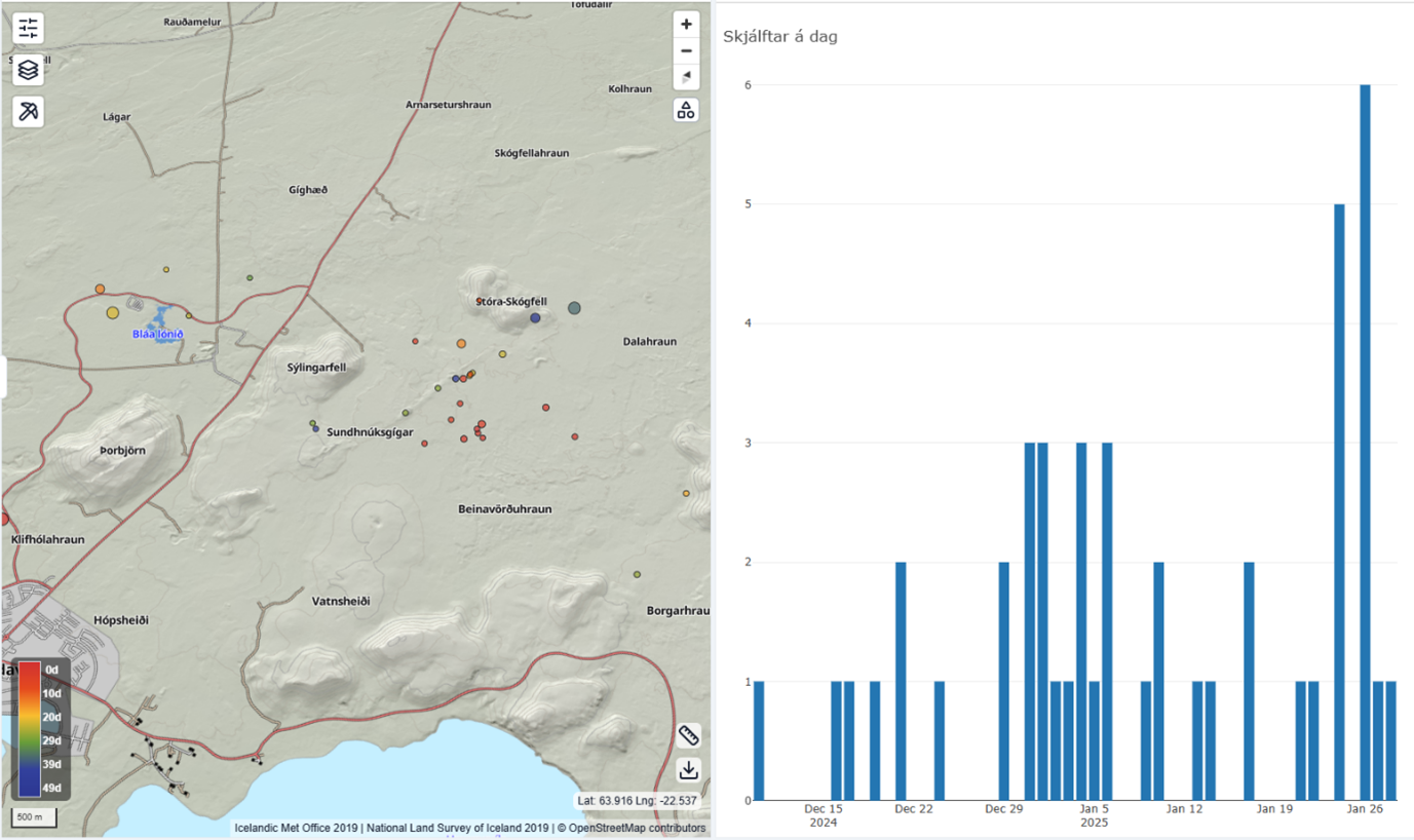
Seismic activity near the Sundhnúkar Crater Row, displaying the number of earthquakes per day since December 2024.

Funny Tee Collections - Laugh You *ss Off and Look Damn Google While doing...
teevibeusa.com/blogs/blog/funny-tee-collection-lau…