
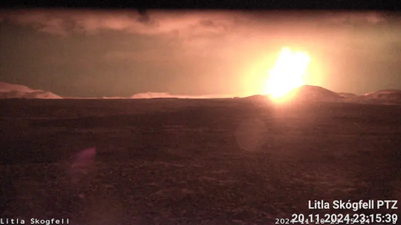
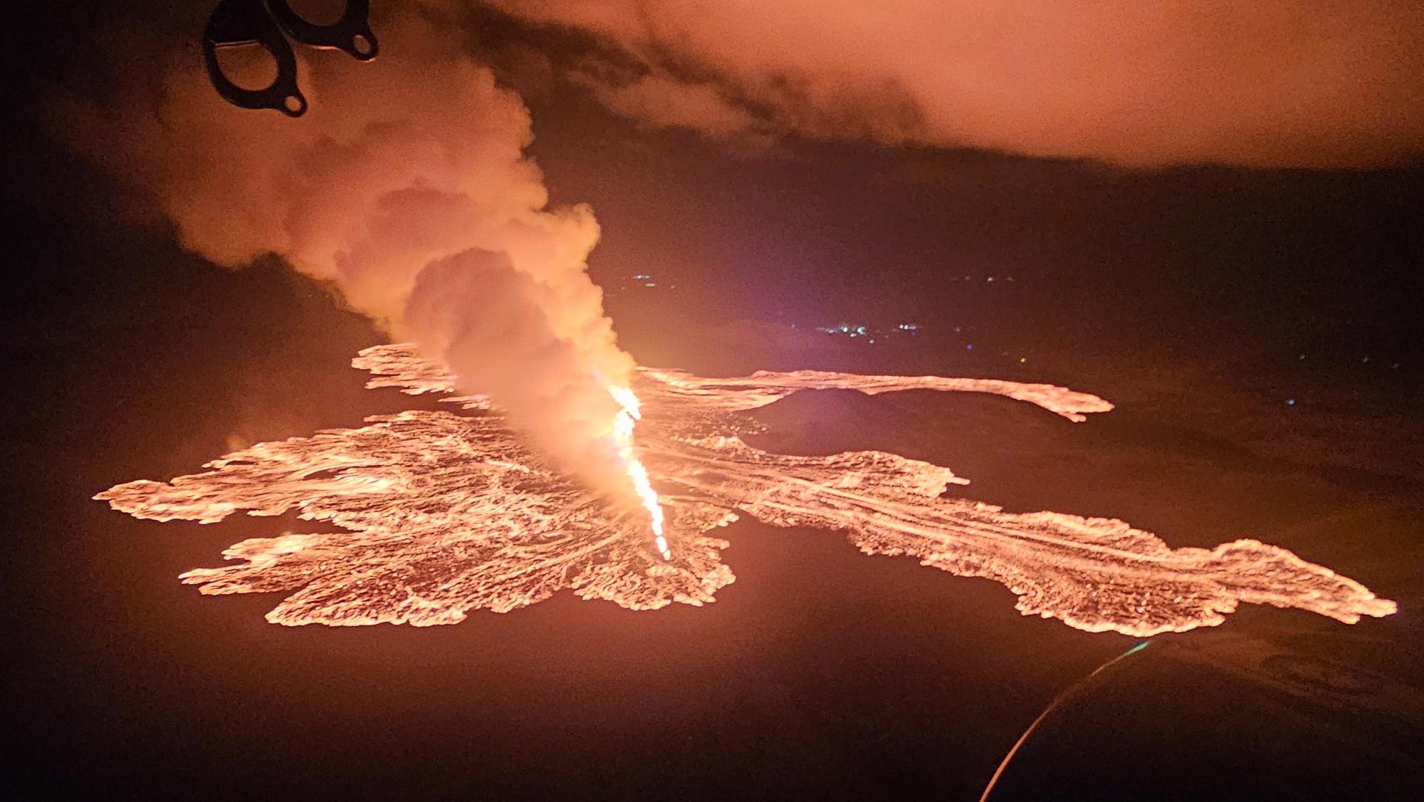
 A screenshot from a webcam about a minute after the eruption began late Wednesday 20 Nov.
From yesterday evening, the eruption turbulence and visible activity of the eruption decreased further, but the activity then stabilized again after midnight. However, there is still considerable force in the eruption and the activity has not decreased as quickly as in previous eruptions in the Sundhnúks crater series. For comparison, it can be mentioned that the lava flow in the eruption at this moment is comparable to the lava flow in the most powerful eruptions in Fagradalsfjall.
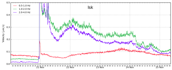
This graph shows the eruption turbulence (green and blue line) since the beginning of the eruption on November 20. A sharp drop in eruption turbulence occurred on the morning of November 24, and a further drop in the evening of the same day. By comparing the turbulence graph in this eruption with the turbulence graph of previous eruptions, it can be seen that the activity in this eruption has not decreased as quickly as in previous eruptions in the Sundhnúks crater series.
The northernmost crater is the most active, and from it the lava flow now runs to the east. During the night, magma sputtered from time to time above the rim of the southernmost crater, but no activity has been seen in it today. The same applies to the central crater, which was the most active crater in the first days of the eruption, but activity in it significantly decreased yesterday and no activity is visible in it today in web cameras.
The lava flow that has flown to the west has slowed down and cooled on the surface. However, it can still be expected that the lava flow will continue below the surface towards the defense walls at Svartsengi and Bláa Lónið, even though its flow has slowed considerably.
Experts from the Institute of Natural Sciences measured the spread of the lava on Saturday, when the eruption had been going on for about 3 days. According to those measurements, the total volume of lava was about 43 million cubic meters and it covered about 8.5 square kilometers of land. This is about 65% of the volume that erupted in the last eruption that lasted 14 days.
Land continues to subside in Svartsengi, but it has slowed down compared to the subsidence at the beginning of the eruption. It is still too early to say whether magma accumulation will continue under Svartsengi. The lava flow of the eruption needs to be further reduced before it can be said that magma accumulation will continue.
Today, the wind direction is changing and will change, so it can be expected that gas pollution can spread around the surrounding area in the southwestern half of the country. See the gas distribution forecast and real-time measurements on the Environment Agency's website
The Norwegian Meteorological Agency has issued an updated risk assessment and it is unchanged from the last time. The risk assessment is valid until 15, Wednesday, November 27, with everything unchanged.
Updated November 24 at 2:30 p.m
Effervescence has subsided
Three craters remain active
Less activity in the most powerful crater yet
The flow of lava towards the dykes at Svartsengi has decreased
The risk assessment is valid until November 25, all things being equal
Activity last night was fairly stable up front, but at 5 o'clock this morning the eruption subsided and, along with that, the visible activity in the central crater, the crater that has been the most active so far, decreased.
Three craters are still active, the southern one has been the smallest in recent days, but activity in it, as well as in the northernmost crater, seems to be fairly stable. The central crater has been feeding a series of lava flows along Stóra Skógfell and further along the defenses at Svartsengi and Bláa lónid. Decreasing activity in it should result in less lava flow to the dikes at Svartsengi.
It should be noted that despite the decreasing activity in the craters, lava flows can still put pressure on dikes. During the June eruption, lava flows broke through a dike, despite the fact that activity at the fissure was significantly reduced at the time.
Gas pollution (SO 2 ) has been measured in Grindavík last night and this morning. We advise people in the area to monitor air quality measurements in real time on the Environmental Agency's website loftgaedi.is , where you can also find information on reactions to gas pollution caused by volcanic eruptions.
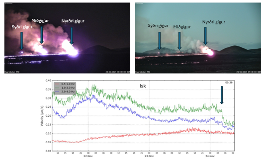
The attached image shows a disturbance graph from a seismometer at Litla-Skógfell. Green line shows eruption turbulence, which has a sharp decrease around 5 this morning. Photo of the craters, from a VÍ webcam north of Fagradalsfjall. On the left is from midnight and on the right is from 9:30 this morning
Updated November 23 at 15:25
Pretty steady fort in three craters since yesterday
Lava flows to the west are putting pressure on the dikes
The situation is sensitive in terms of the possible impact on infrastructure in and around Svartsengi due to lava flow
The risk assessment is valid until November 25, all things being equal
The eruption at Sundhnúksgíga continues. The fissure is still erupting in three defined areas and the most active is located around its middle. Activity has remained fairly steady overnight and so far throughout the day.
The eruption is stable and no earthquakes have been recorded in the area. Land subsidence is measured at nearby GPS stations, as more magma flows to the surface than is able to accumulate in a magma chamber.
Lava still flows to the west and it flows along the defenses at Svartsengi and Bláa Lónið and thickens. Lava also flows to the north and east from the northernmost and southernmost craters. Lava flows to the west are putting pressure on defense walls, and the situation is sensitive in terms of the possible impact on infrastructure in and around Svartsengi due to lava flows.
Weather watch's forecast for gas pollution : It is forecast to continue to be somewhat stiff in the northeast and northwest today (Saturday) and tomorrow. Gas pollution then travels to the southwest and south towards Grindavík and Svartsengi. Wildfires are not expected.
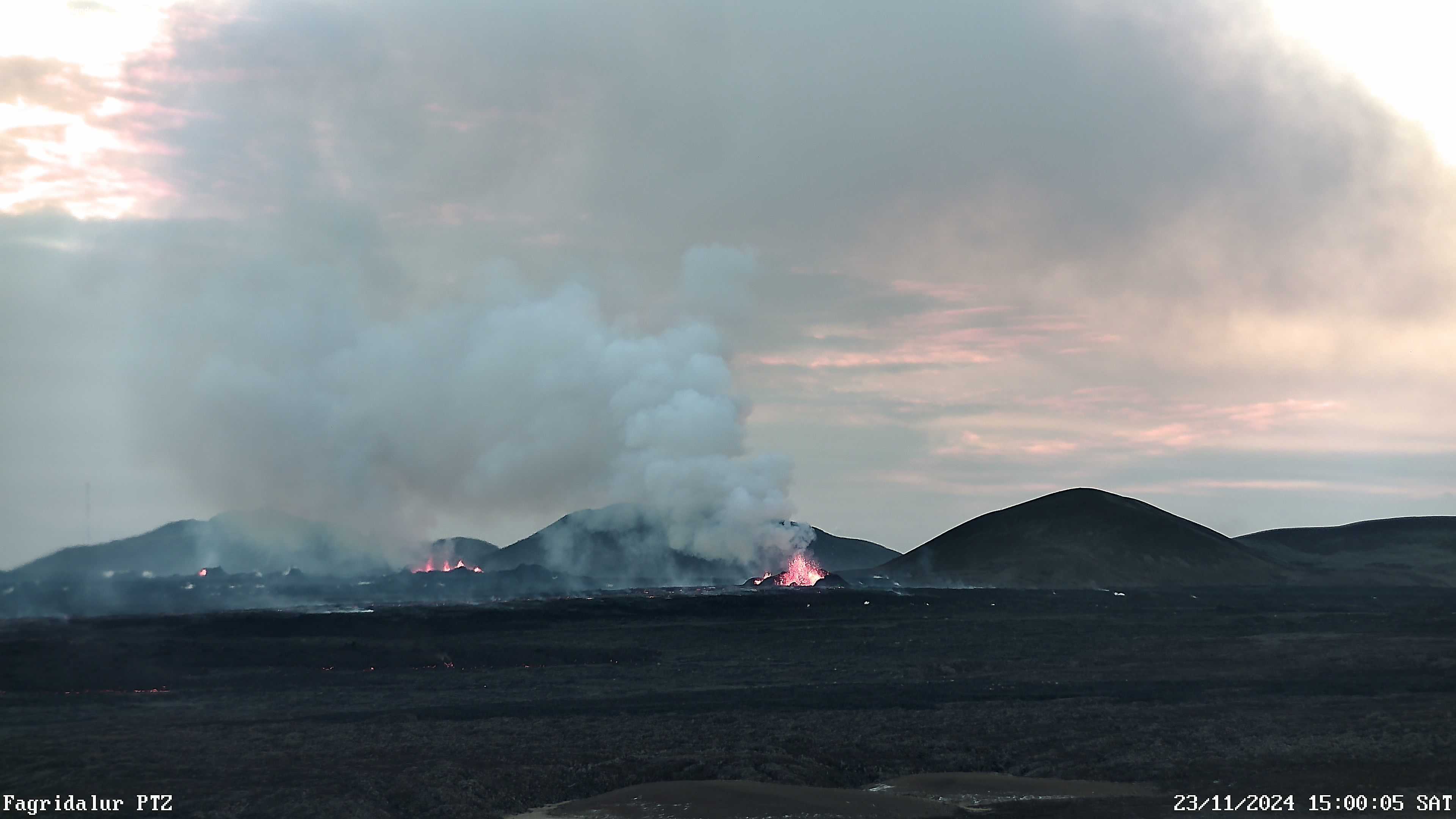
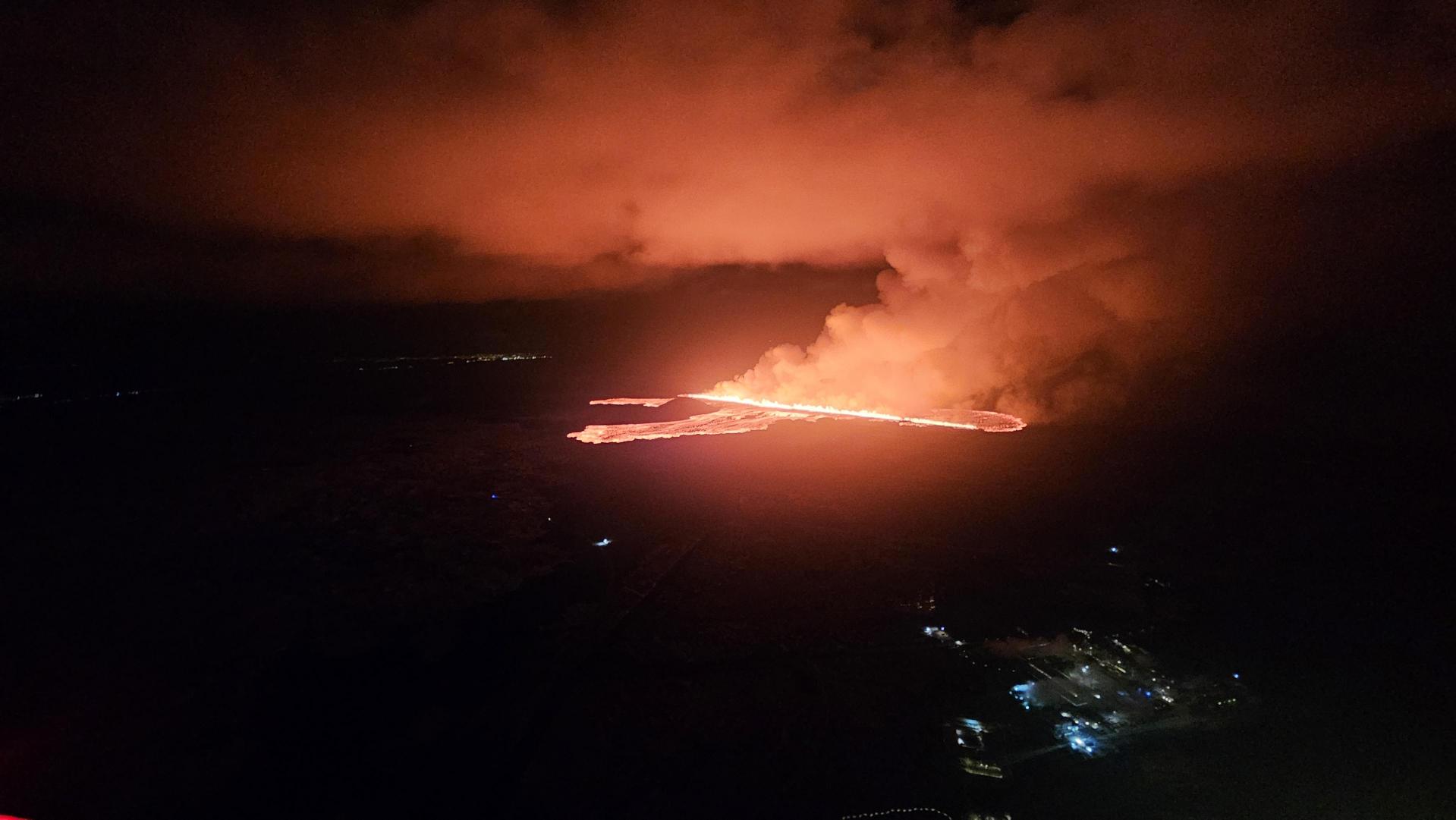
Screenshot from a webcam at Fagradalsfjall at 15:00 today, November 23, showing the three most active locations on the eruption.
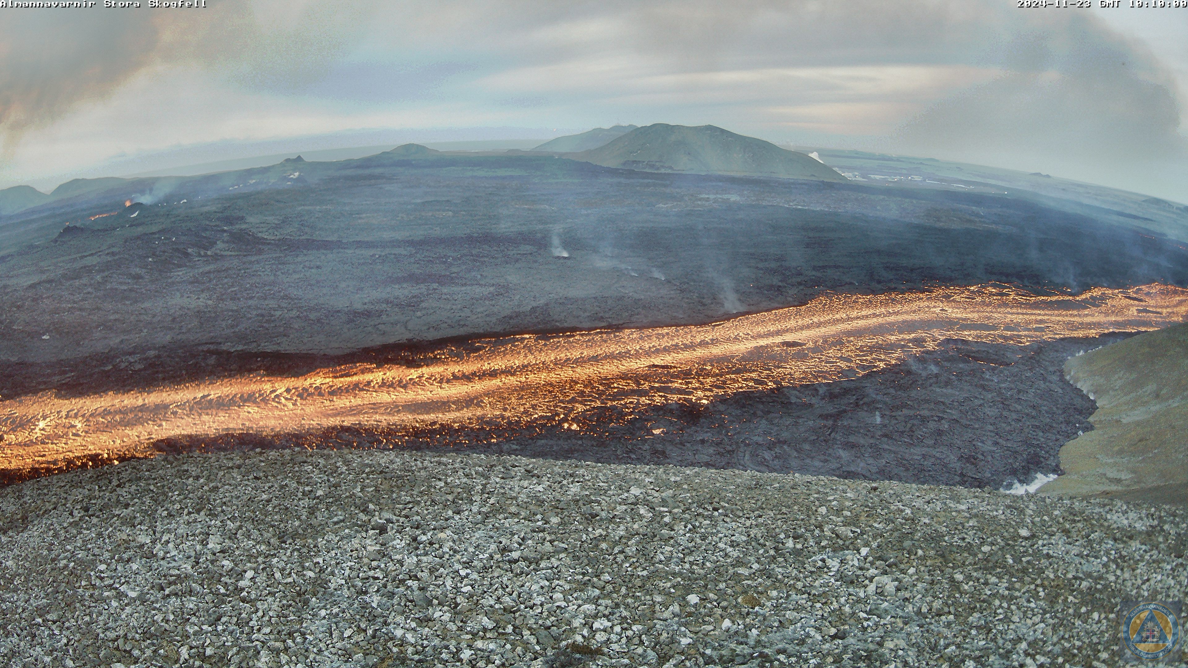
A screenshot from a webcam taken during the light transition this morning, November 23, showing a lava river along the southern slopes of Stóra-Scógfell. The lava flows to the west and adds to the lava tongues that are putting a strain on the dikes at Svartsengi.
Updated November 22 at 14:50
Since yesterday, three areas have been active on the fissure between Stóra-Skógfell and Sýlingarfell. Activity in them was quite stable last night, but the most activity is in the crater in the middle. Small changes have been observed in the eruption turbulence, which is consistent with the constant activity in the eruption. The lava flow is mainly to the west, and that lava stream comes from the crater in the middle, while lava from the southern and northern parts of the fissure mostly flows to the east, but does not threaten any infrastructure there.
The advance of the lava north of the defense walls at Svartsengi has slowed considerably. The hrauntungan there has encountered an obstacle in the landscape and it spreads to the north from the defenses and thickens. Compared to the initial phase of the eruption, the flow of lava from the fissure has decreased significantly, but there is still considerable flow from the active craters, especially to the west.
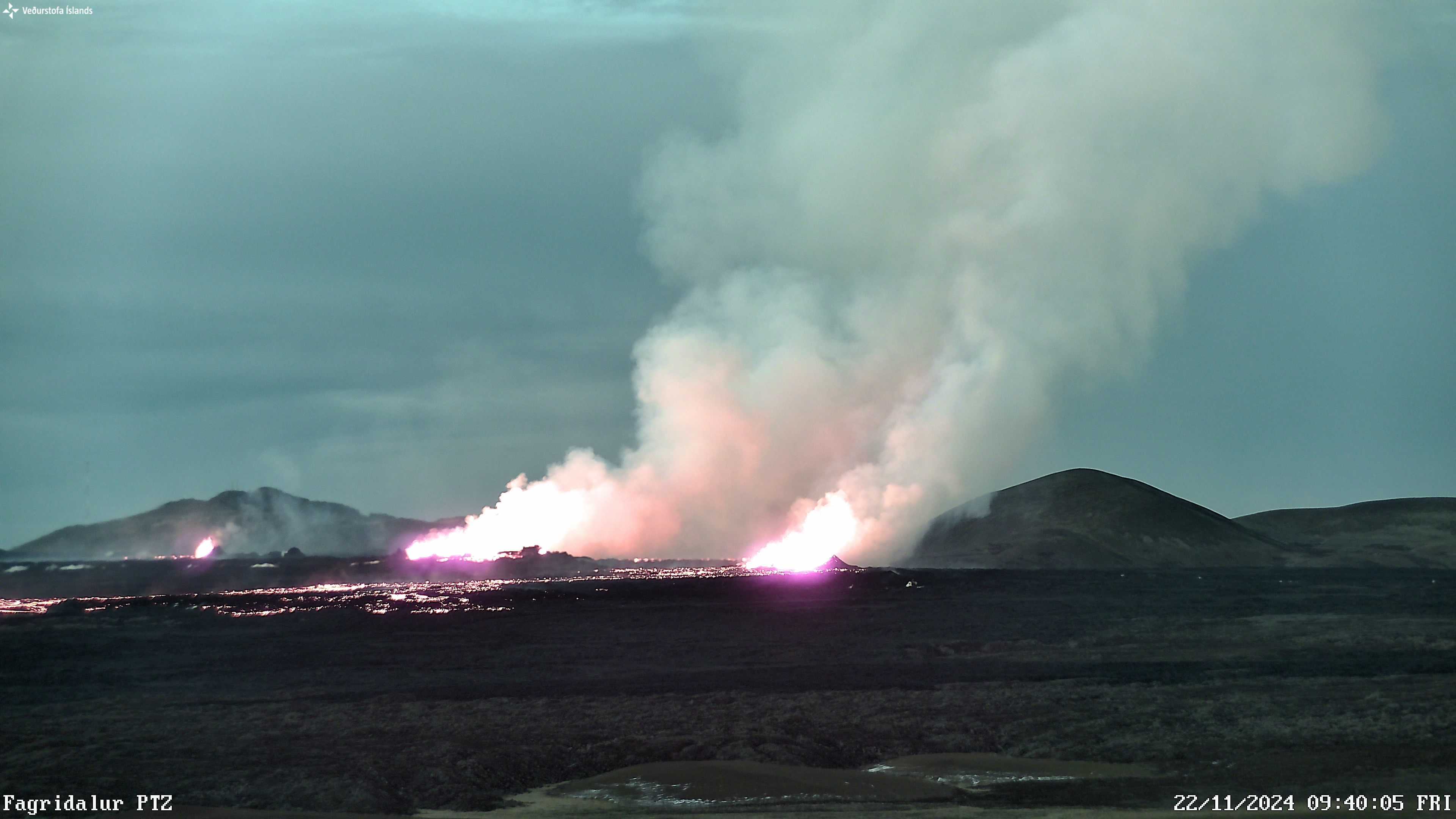
Photo taken at 9:40 this morning with a web camera of VÍ in Fagradal. The plane looks to the southwest and shows three active areas on the fissure. On the right side of the picture you can see Stóra-Scógfell and on the left side in the background is Þorbjörn.
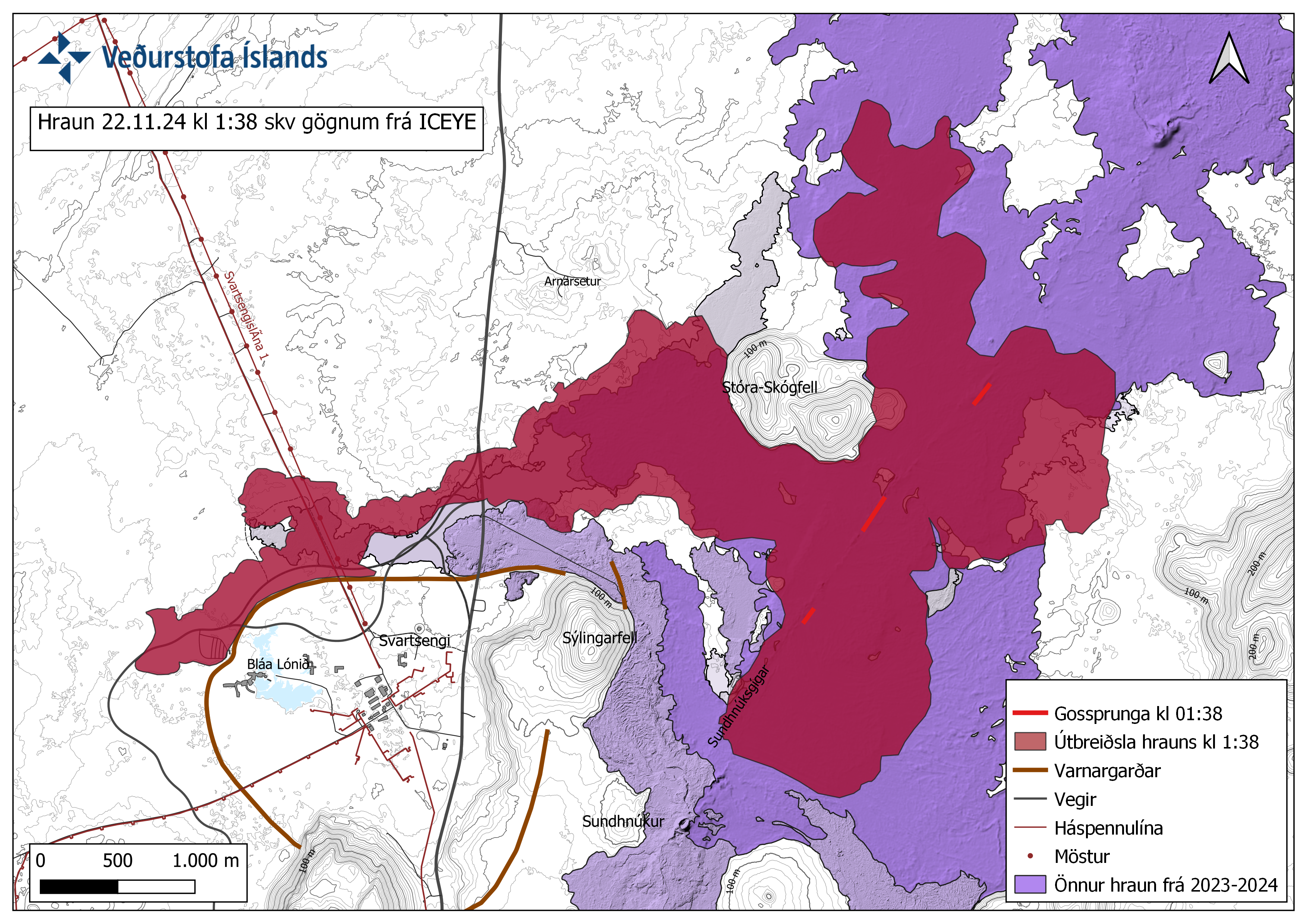
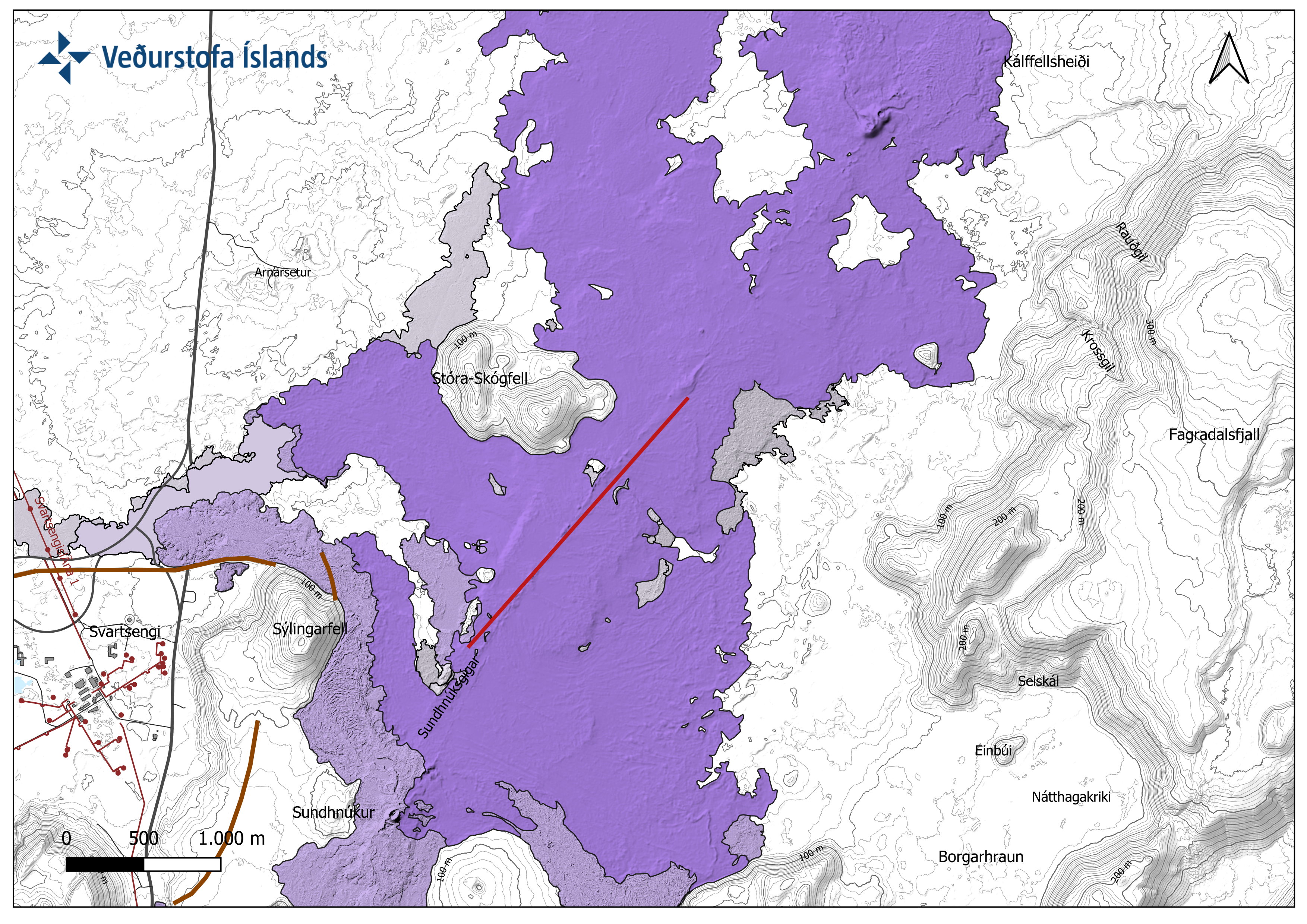
The map shows the extent of the lava as it was at 01:38 according to ICEYE satellite image.
Land continues to sink in Svartsengi, which is consistent with considerable flow still in the eruption. About 10 million cubic meters of magma flowed from the magma chamber in the first hours, which is about half of the volume that had accumulated in the magma chamber since the last eruption. The development of the subsidence in Svartsengi is comparable to what was seen at the beginning of the last two eruptions. Land subsidence can be expected while the flow in the eruption remains high.
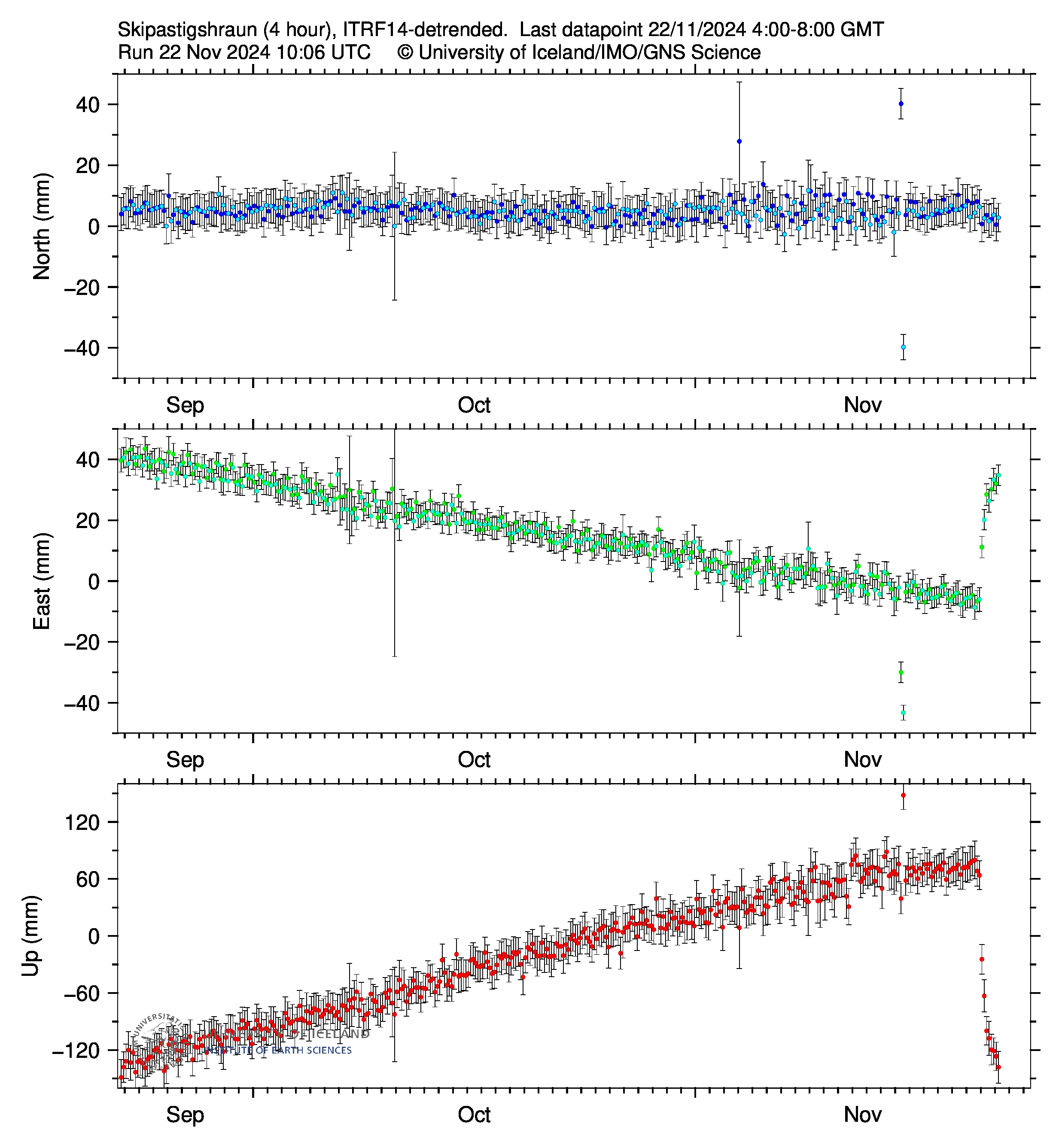
Records at the GPS station SKSH (Skipastígshraun) in Svartsengi since mid-September to the north, east and vertically (top, middle, bottom). Measurement points are every four hours and the latest measurement since 8 this morning (November 22) continues to show itself in the Svartsengis area (Photo from the University of Iceland).
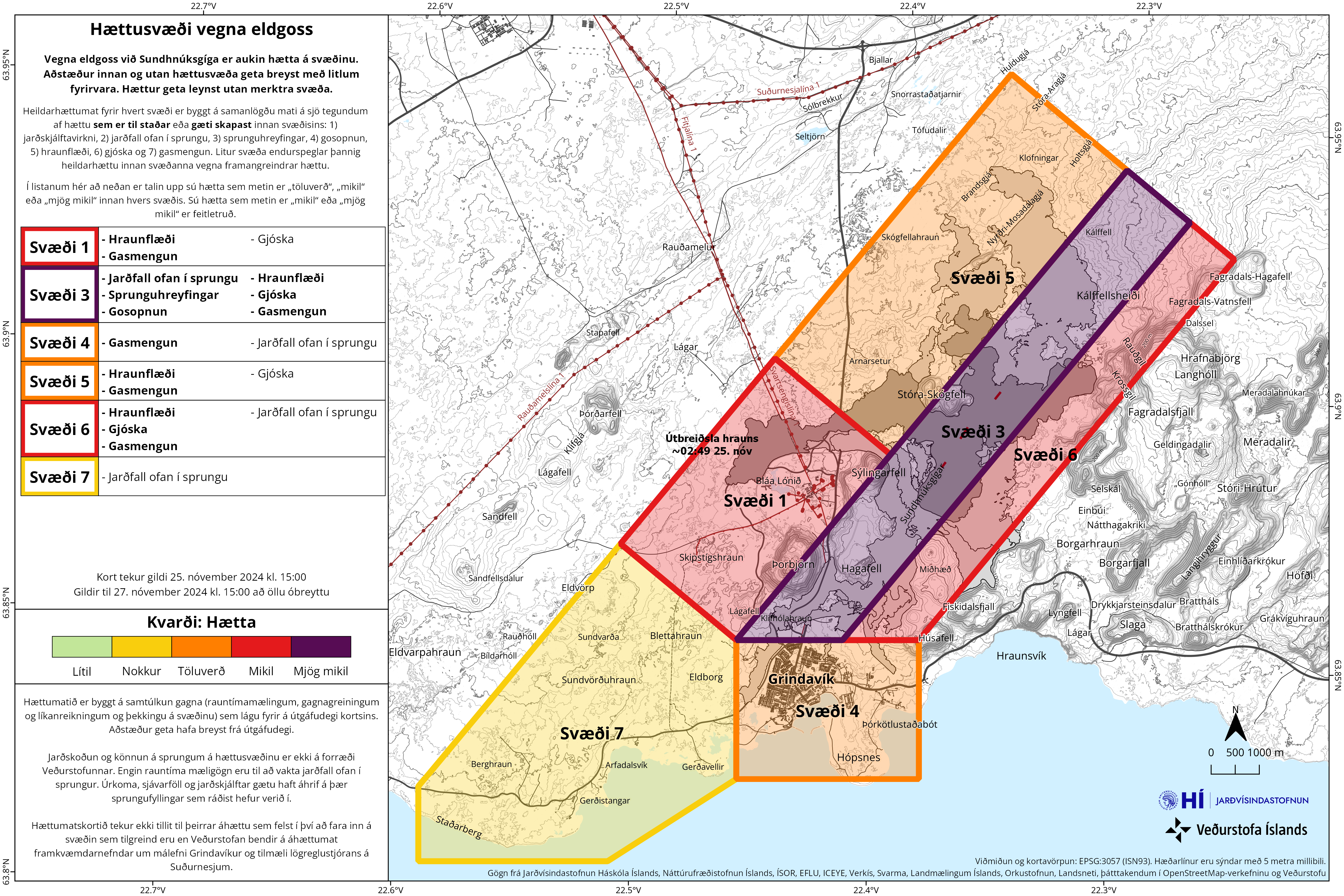
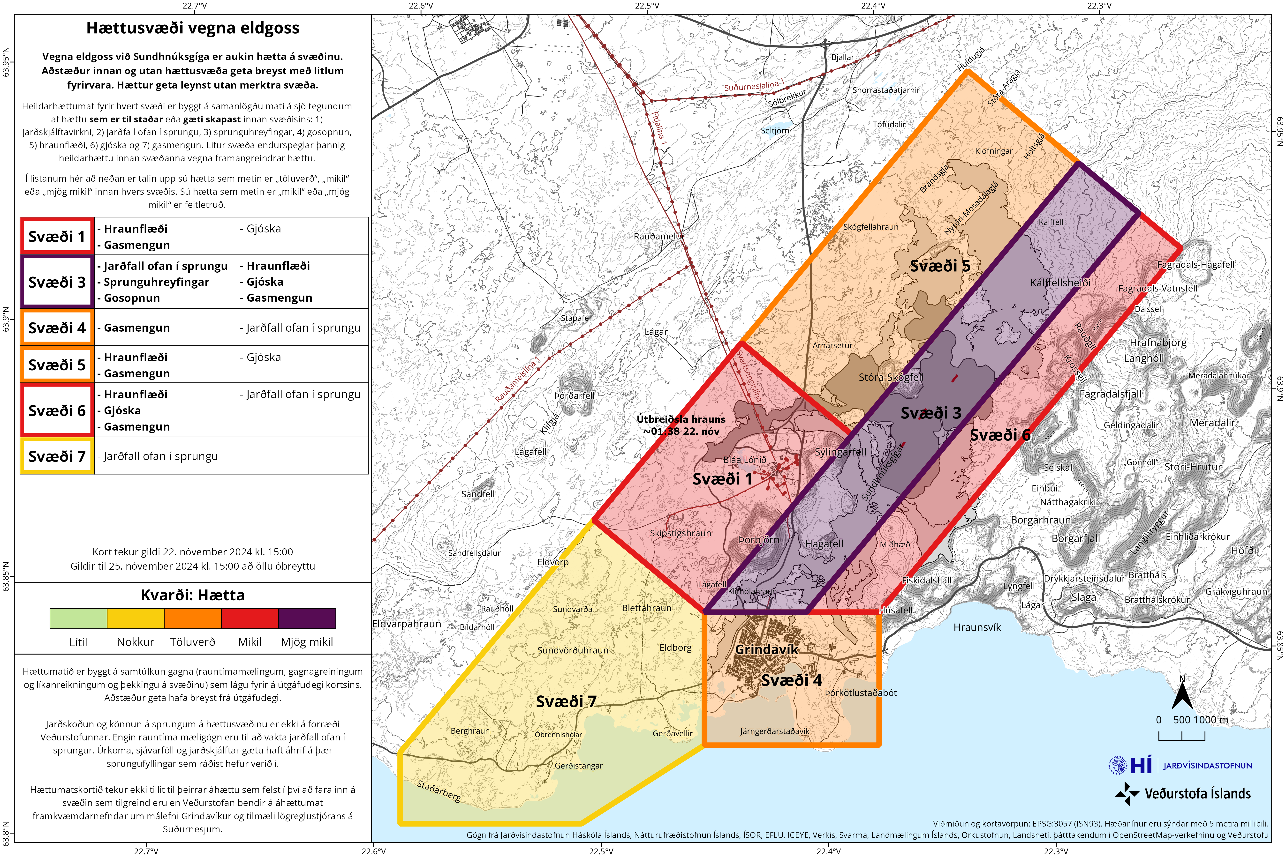
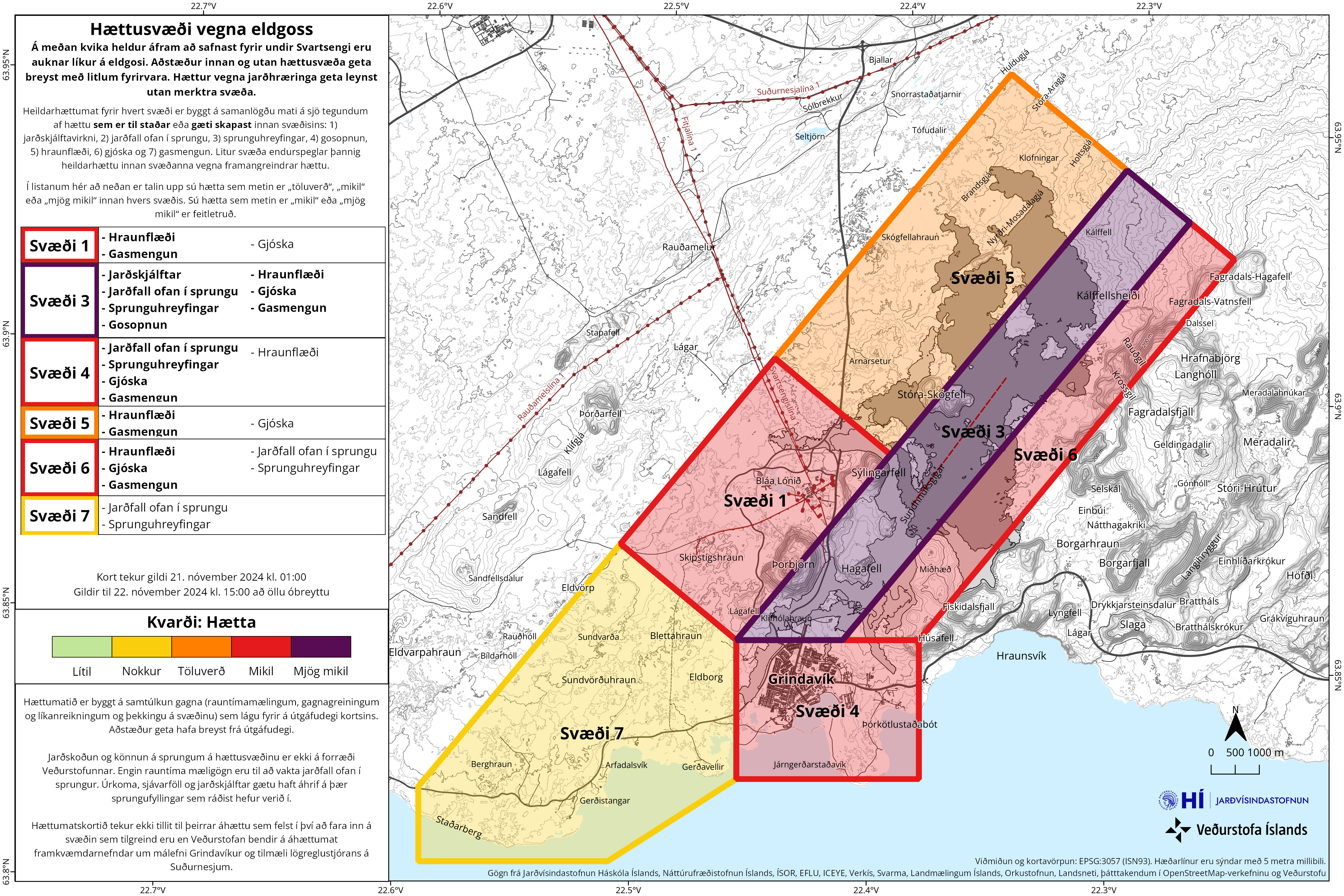
The risk assessment has been updated and remains valid until 15:00 on November 25. The main change is that the overall risk in area 4, Grindavík, is now assessed as considerable (orange). According to the measurements and visual inspection carried out by the ground survey team Ísor, Efla and Verkís yesterday, there were no clear signs of new movements on the cracks and no new cracks were visible within Grindavík. Therefore, the risk of landslides and fissure movements has been reduced and is now assessed as before the start of the current eruption. The risk of lava flow and pyroclastic fall is also estimated to be lower in zone 4 as there is no lava heading towards the town. Due to the prevailing wind direction in the coming days, the risk of gas pollution is estimated to be very high. No changes in overall risk in other areas.
Today's gas distribution forecast is a northeasterly direction, and tomorrow gas pollution will travel to the southwest towards Grindavík and Svartsengi. Wildfires are not expected. You can follow the gas distribution forecast on our website. You can also monitor air quality on the Environment Agency's website.
Updated November 21 at 4:15 p.m
Lava never flowed this far to the west
Seismic activity and deformation very low
The advance speed of the lava was estimated at over 100m per hour today
The risk assessment will be updated tomorrow, November 22, all things being equal
Activity in the volcanic eruption between Stóra-Scógfell and Sýlingarfell seems to be quite similar since this morning. Seismic activity and deformation of the eruption centers is very low.
Initial measurements indicate that the volume of magma that flowed from Svartsengi into the Sundhnúks crater series is almost half of the volume that flowed from Svartsengi during the eruption on August 22. More detailed results will be available in the coming days.
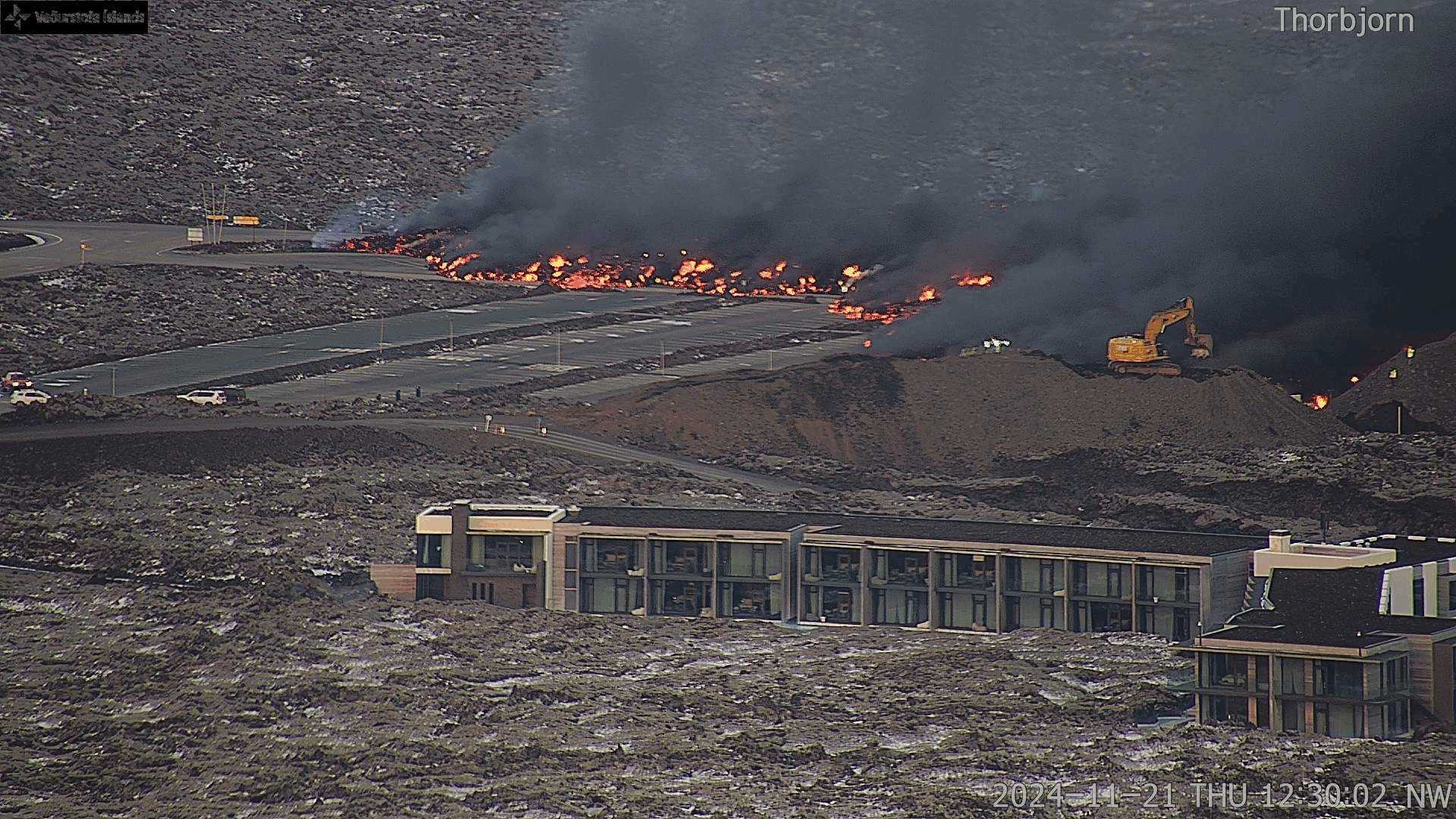
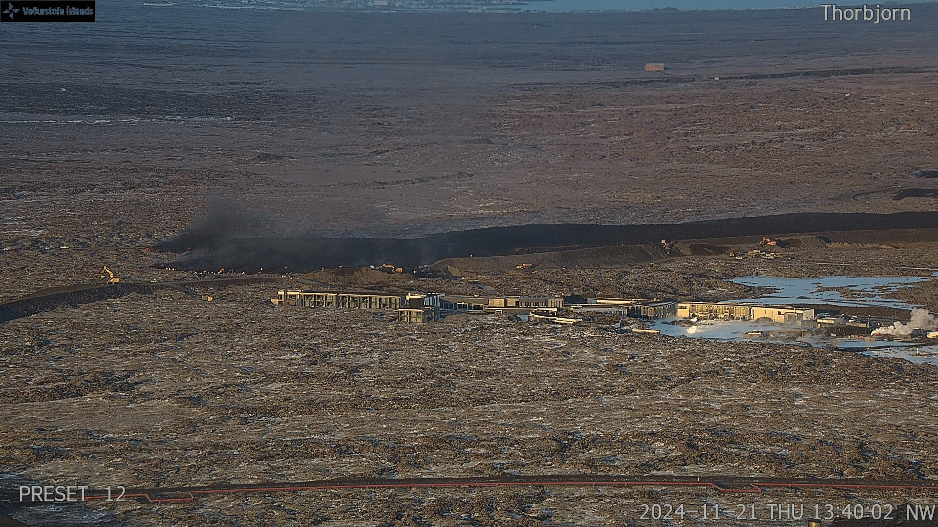
The lava tongue that flowed over Grindavíkurveg and the hot water pipe west of it has continued to flow to the west. At noon, the lava reached the parking lot at the Blue Lagoon and is still moving. The advance speed of the lava was estimated at over 100m per hour between 12:09 and 1:35 p.m.
This lava bed has now reached further to the west than lava beds from previous eruptions. The attached photos are taken from the Met Office's web camera, which is located up in Þorbirn. The first video is taken between 12:30 and 12:50 today and later from 13:40 - 14:30. They show the progress of the lava at that time.
Updated November 21 at 11:00 am
The eruption that began at 11:14 p.m. on November 20 continues, but the activity on the fissure has decreased about 600 meters from the southern end, according to drone measurements by the National Police Commissioner's special unit. The activity is now greatest around the middle of the fissure, between Stóra-Skógfell and Sýlingarfell. Lava flowed over Grindavíkurveg from half past five last night. Shortly before 8 o'clock this morning, the lava tube also reached the hot water pipe, Njarðvíkuræð.
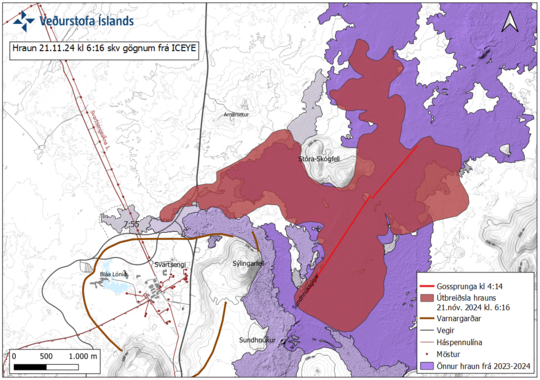
According to a satellite image (ICEYE) at 6:16 this morning, the lava spread has reached almost 7 square kilometers. The outline of the lava bed is roughly shown on the attached map.
Seismic activity decreased significantly shortly after the eruption began, and since then only a few earthquakes have been recorded. Deformation was measured in the first hours after the eruption began, but little deformation is now measured around the eruption fissure.
According to the weather watch's forecast for gas distribution, today (Thursday) the direction is northeast, and tomorrow (Friday) gas pollution will reach the south and west of the eruption centers. It is likely that gas pollution will be noticed in Grindavík, Svartsengi and Reykjanesbær. Wildfires are not expected.
The satellite image shows the plume reaching the south at 04:41 am where the main part of the mackerel is SO2 gas. From the time the eruption began and until the night there was a northerly direction that turned to the east in the early morning.
The Norwegian Meteorological Agency updated the danger assessment last night (November 20), which is valid until 15:00 on November 22, all things being equal. Danger has increased in all zones except zone 7. High danger (purple) is in zone 3, where the source of the eruption is. In zones 1, 4 and 6, the risk has been increased to high (red).
Updated November 20 at 01:45
The length of the fissure is estimated at 3 km and its southern end is at Sýlingarfell
The news thread will be updated next at 10:00 am. The Met Office's 24-hour watch will publish posts on Facebook if there are major changes in the activity of the eruption tonight.
The activity in the eruption seems to have reached its peak. The fissure has stopped expanding and according to the signs that can be seen on the meters of the Norwegian Meteorological Agency, there seems to be no indication that the activity will increase.
The length of the eruption is estimated to be around 3 km. The lava flow spreads both east and west. There is no lava flow towards Grindavík. At this point, there are about 500m from the edge of the lava to the west to Grindavíkurvegi.
The current eruption is considerably smaller than the last eruption that began on August 22. The estimated lava flow at this moment is about 1,300m 3 /s, but it was about 2,500m 3 /s in the August eruption.
What is interesting is that the seismic activity did not increase in the weeks before the eruption, as had happened in previous events. The amount of magma that had accumulated under Svartsengi was similar to that before the last eruption. However, the recent trend has been that more and more magma has had to accumulate to trigger the next event. This is an indication that the patterns seen so far in past eruptions may be changing.
(Photo: Public Safety/Björn Oddsson)
Entry at 01:20
Weather watch's gas distribution forecast: Northerly tonight, gas pollution blows to the south of the eruption centers, but tomorrow (Thursday) more easterly winds are forecast, i.e. gas pollution reaches the west and southwest. It is likely that gas pollution will be noticed in Grindavík, Svartsengi and Reykjanesbær.
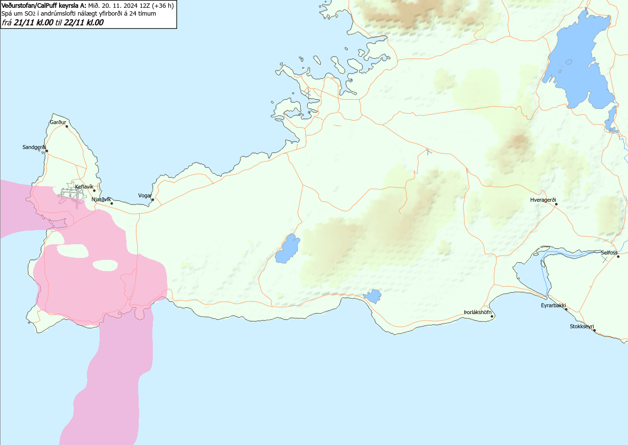
A picture showing where gas pollution can be expected in the next 24 hours.
Entry at 01:09

Revised location of the eruption based on information from the Coast Guard's surveillance flight.
Entry at 00:21
The length of the fissure is estimated at 2.5 km and its southern end is at Sýlingarfell. Based on the situation now, this eruption is smaller than the last eruption.
It cannot be ruled out that the eruption will continue to grow. At this moment, there are no indications to be seen on the Met Office's gauges that the eruption is extending to the south.
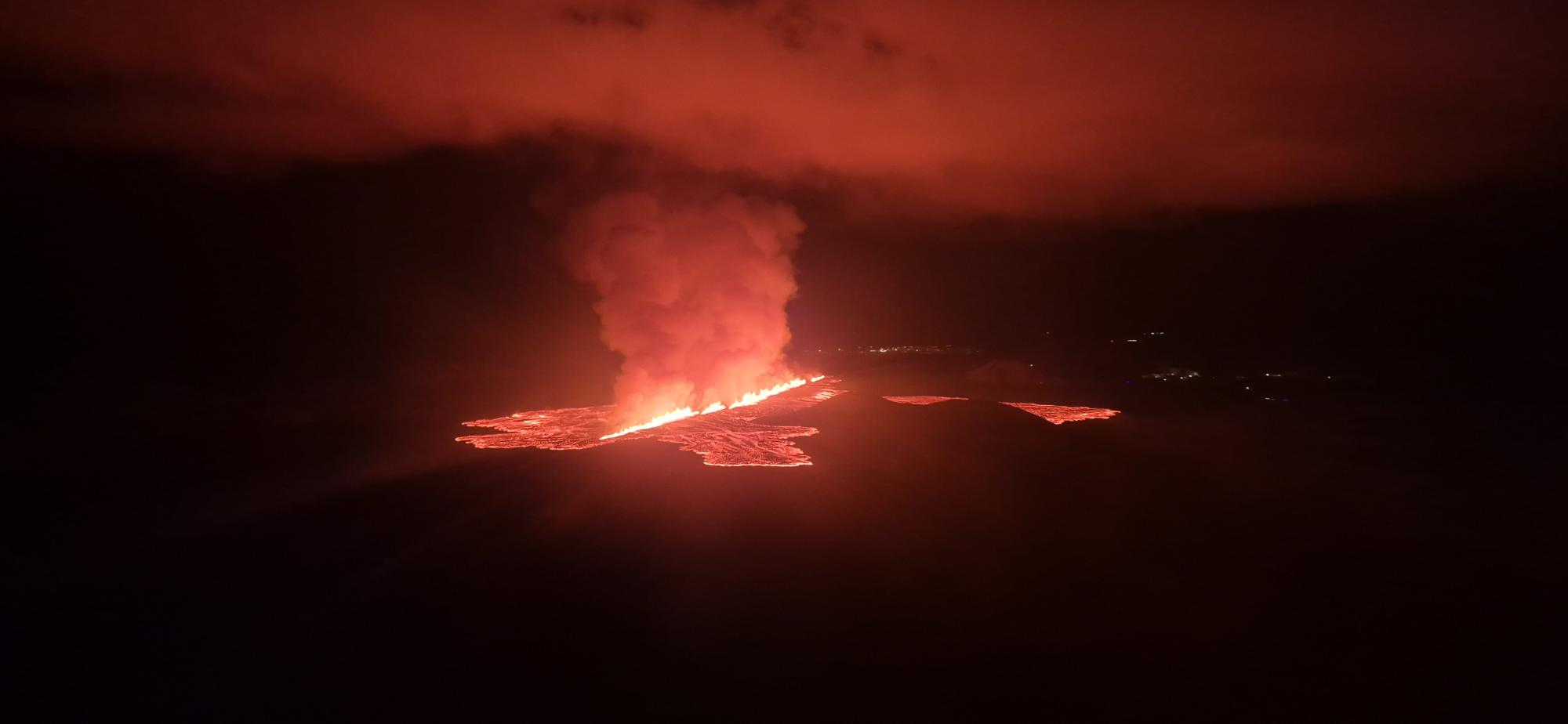
The first photo from a patrol flight with the Coast Guard. The lights in Grindavíkurbær can be seen in the distance. The lights in Svartsengi on the right side of the picture. (Photo: Public Safety/Björn Oddsson)
A picture showing a lava flow to the west towards Grindavíkurvégur. The lights in the HS Orku power plant in the foreground. (Photo: Public Safety/Björn Oddsson)
Entry at 11:50 p.m
The series of small earthquakes started around At 22:30 and around 22:37, pressure changes were measured in HS Orku's boreholes, which were a clear sign that magma flow had begun.
At 23:14, a fissure opened between Stóra-Skógfell and Sýlingarfell. The eruption expanded to the northeast.
The first news about the lava flow indicates that the lava stream flows to the west and lies to the south in Stóra-Skógfell. No lava flow can be seen in the direction of Grindavík.
There is a strong northerly direction in the area, which directs gas pollution southwards over Grindavík.
The Coast Guard helicopter is taking off. Information from that flight will give a more detailed picture of the direction of the lava flow.
A map showing the approximate location of the eruption at 11:40 p.m. The location is based on radar data.

Funny Tee Collections - Laugh You *ss Off and Look Damn Google While doing...
teevibeusa.com/blogs/blog/funny-tee-collection-lau…