
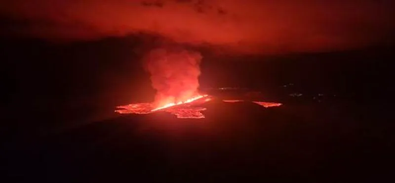
 The fissure opening taken from the Coast Guard helicopter. Lights in the town of Grindavík seen in the distance. (Photo: Civil Protection/Björn Oddsson)
Activity has not decreased as quickly as it did in previous eruptions.
The rate of the flowing lava is comparable to the strongest eruptions at Fagradalsfjall.
The advancing lava flow may be exerting stress on the protective barriers at Svartsengi.
The hazard assessment remains unchanged.
Since yesterday in the early evening, volcanic tremor and visible activity from the eruption have further diminished, but the activity stabilized again after midnight. Nevertheless, the eruption remains quite powerful, and the activity has not decreased as quickly as it had in previous eruptions in the Sundhnúkur crater row. For comparison, the current lava flow is estimated to be on par with the most vigorous eruptions at Fagradalsfjall.
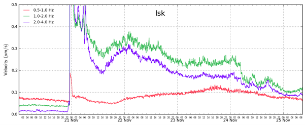
Text: RSAM graph showing the average amplitude of volcanic tremor (green and blue lines) since the eruption began on November 20. A sharp decline in tremor occurred on the morning of November 24, with a further decrease that evening. Comparing the tremor graph of this eruption to those of previous eruptions shows that activity in this eruption has not decreased as rapidly as it did during previous eruptions at the Sundhnúkur crater row.
The northernmost vent is the most active, with the main lava flow now extending eastward from it. Overnight, sporadic splashes of lava were observed above the rim of the southernmost vent, but no activity has been observed there today. Similarly, the middle vent, which was the most active during the first days of the eruption, experienced a significant decrease in activity yesterday, and no activity is visible today on live webcams.
The lava flow that has been travelling westward has slowed and cooled on the surface. However, lava may still continue to flow beneath this solidified crust toward the protective barriers near Svartsengi and the Blue Lagoon, though its advance has significantly slowed.
Experts from the Icelandic Institute of Natural History measured the lava field's spread on Saturday, about three days into the eruption. According to these measurements, the total volume of lava had reached about 43 million cubic meters, covering approximately 8.5 square kilometers. This is roughly 65% of the volume from the last eruption, which lasted 14 days.
Land continues to subside in Svartsengi, though at a slower rate compared to what was observed at the start of the eruption. It is still too early to determine whether magma accumulation will persist under Svartsengi. The flow of lava from eruptive vents needs to decrease further before any conclusions can be made about continued magma accumulation.
Today, wind directions are shifting and becoming variable, meaning volcanic pollution could spread to the surrounding areas in the southwestern part of the country. See the gas dispersion forecast and real-time measurements on the Environment Agency'swebsite
The Icelandic Meteorological Office has issued an updated hazard assessment, which remains unchanged from the previous one. The hazard assessment is valid until 3 PM on Wednesday, November 27, barring any changes.

Updated 23 November 16:00 UTC
Eruptive activity between Stóra-Skógfell and Sýlingarfell continues. Since yesterday, activity in three areas along the eruptive fissure have remained fairly stable.
Seismic activity remains low and land continues to subside at Svartsengi, consistent with significant magma outflow to the eruption.
The lava flow that crossed Grindavíkurvegur and the hot water pipeline to the west has continued travelling westward. The lava flow is causing some strain on the protective barriers around Svartsengi.
Gas dispersion forecast: Northeasterly and northerly wind today (Saturday) and tomorrow. Gas pollution will be advected to the southwest and south towards Grindavík and Svartsengi. Wildfires are not expected.
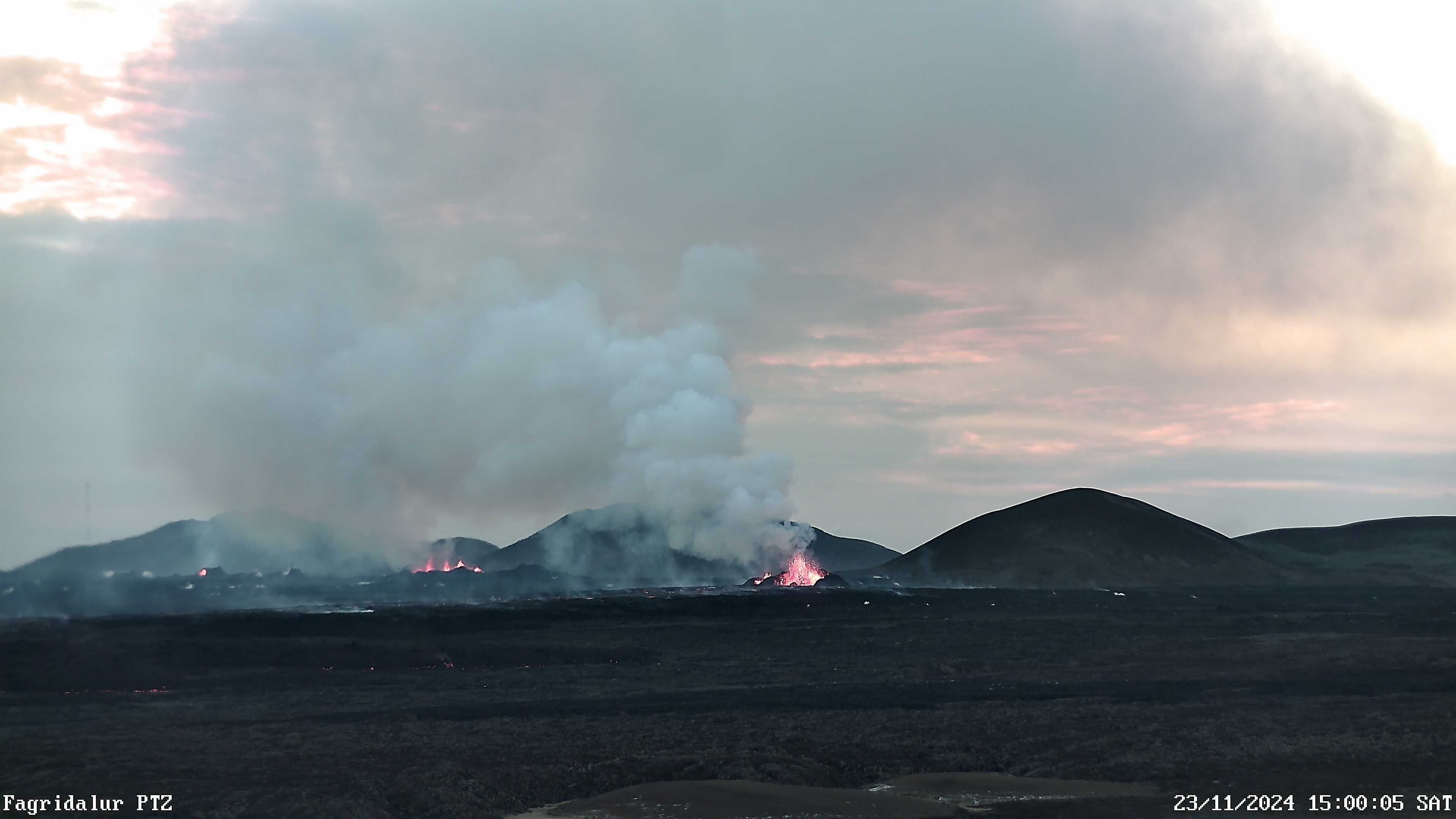
A screenshot from a webcam at Fagradalsfjall showing the activity at 3PM, 23 November.
Updated 22. November at 15:30 UTC
Eruptive activity in three vents has been relatively steady since yesterday
The progression of the lava flow slows significantly near Svartsengi
Land subsidence is occurring at Svartsengi
The hazard assessment has been updated, and it is valid until 25 November if conditions remain unchanged
Since yesterday, three areas along the eruptive fissure between Stóra-Skógfell and Sýlingarfell have been active. Activity in these areas remained fairly stable overnight, with the central vent showing the highest activity levels. Minor changes have been observed in volcanic tremor, consistent with stable activity in the eruption.
The lava is flowing primarily westward, originating from the central vent. Lava from the southern and northern parts of the fissure flows predominantly eastward but poses no threat to infrastructure. Near the protective barriers at Svartsengi, the lava's advance has slowed significantly. The lava tongue has encountered obstacles in the terrain at that location, spreading northward from the barriers and thickening. Compared to the initial phase of the eruption, the lava flow from the eruptive fissure has decreased considerably. However, a significant lava flow persists from the active craters, especially toward the west.
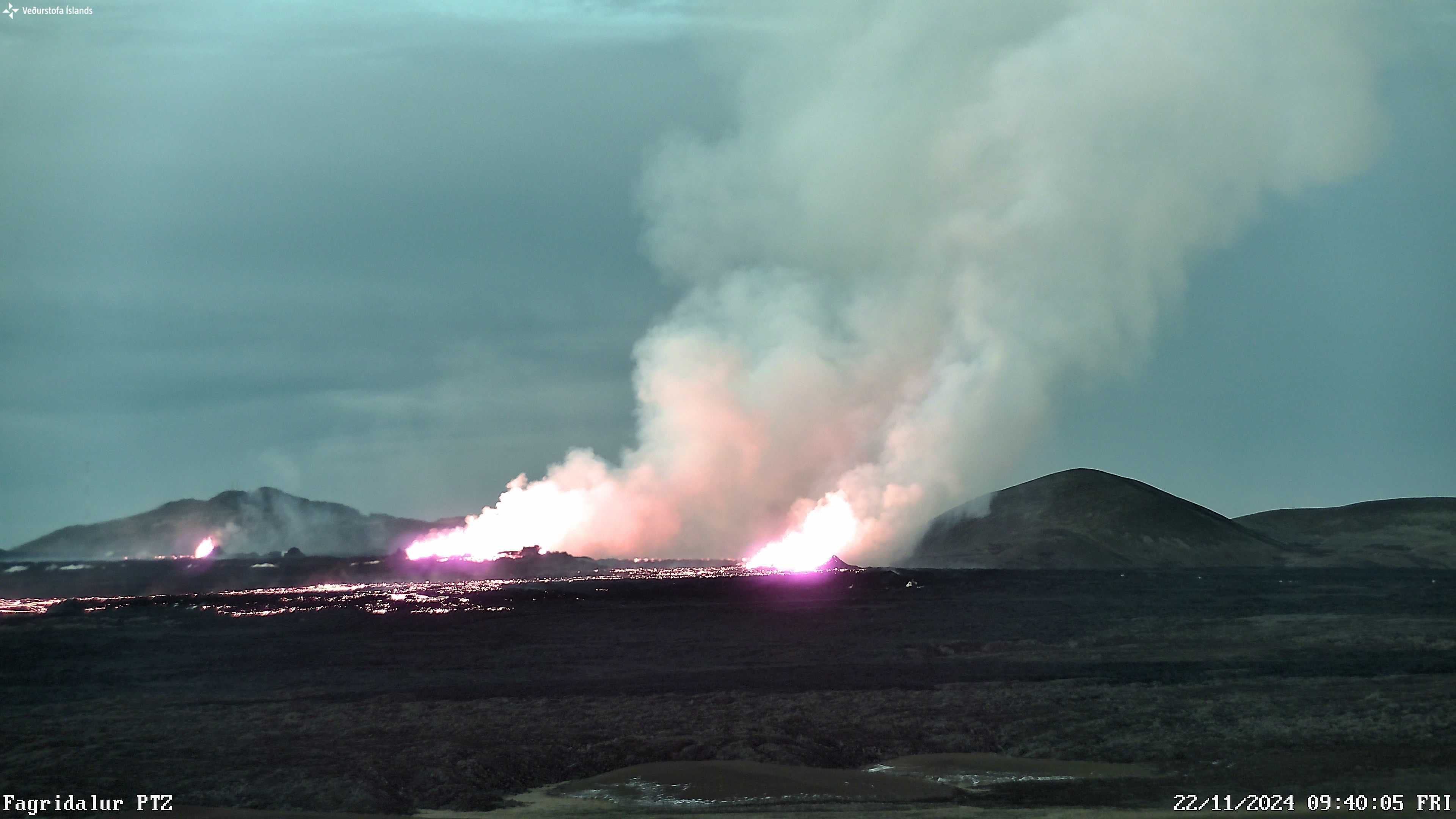
A photograph captured at 9:40 this morning via the Icelandic Meteorological Office's webcam in Fagradalsfjall. The camera faces southwest, showing three active areas along the eruptive fissure. Stóra-Skógfell can be seen on the right side of the image, while Þorbjörn appears in the background on the left.

Map showing the extent of the lava flow as of 1:38 AM, based on satellite imagery from ICEYE.
Land continues to subside at Svartsengi, consistent with significant magma outflow to the eruption. Approximately 10 million cubic meters of magma erupted during the first few hours, representing about half of the volume that had accumulated in the magma chamber since the last eruption. The pattern of subsidence at Svartsengi is similar to what was observed during the initial phases of the last two eruptions. Land subsidence is expected to continue as long as the injection of magma from the reservoir towards the eruptive fissure remains high.
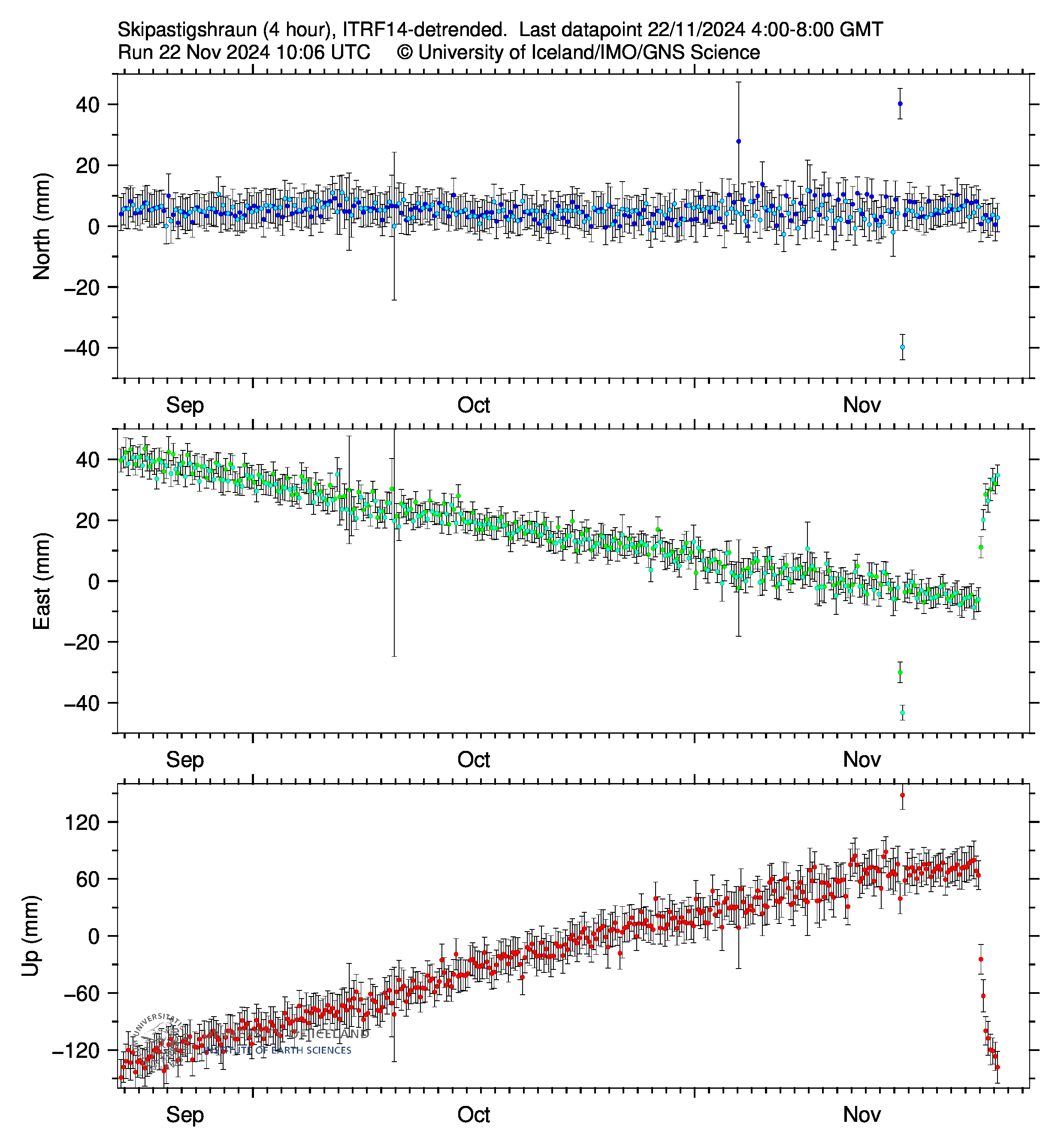
Displacement at the GPS station SKSH (Skipastígshraun) in Svartsengi since mid-September, showing the north, east, and vertical component (top, middle, bottom). Measurements are taken every four hours, and the most recent reading from 8:00 AM this morning (22 November) indicates continued subsidence in the Svartsengi area. (Image courtesy of the University of Iceland.)
The hazard assessment has been updated and, barring any changes, is valid until 3:00 PM on 25 November. The main update is that the overall risk in Zone 4 (Grindavík) is now assessed to be considerable (orange).
According to measurements and visual inspections conducted yesterday by geological survey teams from ÍSOR, EFLA, and Verkís, there were no clear signs of new fractures or movements on existing fractures in Grindavík. As a result, fissure-related ground collapse has been downgraded as a hazard to the level it was before the present eruption began.
The possibility of lava flow and ashfall in Zone 4 (Grindavík) is assessed to be lower since no lava is moving toward the town. However, because of prevailing wind conditions in the coming days, gas pollution levels could be high in Grindavík. There are no changes to the overall hazard levels in other areas.
Gas Dispersion Forecast: Today, a northeasterly wind is expected, and tomorrow gas pollution will move southwest toward Grindavík and Svartsengi. No moss fires are anticipated. You can follow the gas dispersion forecast on our website, as well as monitor air quality on the Environmental Agency's website. 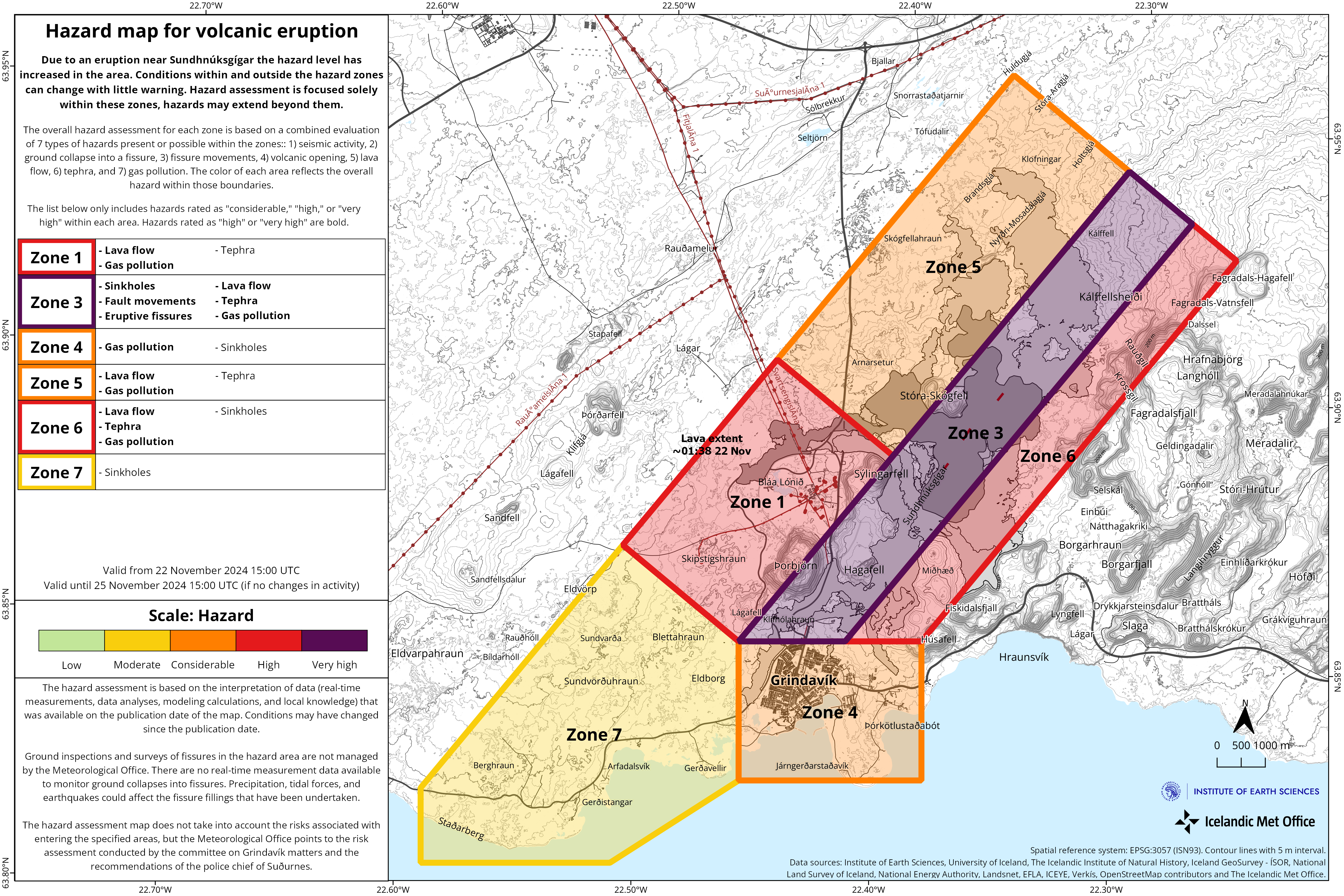
Updated 21. November at 16:45 UTC
Eruptive activity between Stóra-Skógfell and Sýlingarfell appears to be similar to that observed earlier this morning. Seismic activity and deformation at the eruption site remain very low.
Initial measurements suggest that the volume of magma that has travelled from Svartsengi towards the Sundhnúkur crater row is equivalent to half the volume that moved during the eruption on August 22. More detailed results are expected in the coming days.
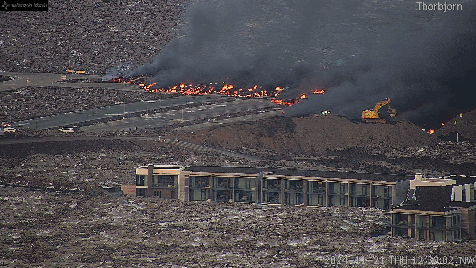
The lava flow that crossed Grindavíkurvegur and the hot water pipeline to the west has continued travelling westward. By midday, lava reached the parking lot at the Blue Lagoon and continues to advance. The rate of advancement was measured to be over 100 meters per hour between 12:09 and 13:35.
This lava field has now extended farther west than any lava flow from previous eruptions. The accompanying images, captured by an IMO webcam positioned on Þorbjörn, show the lava's progression as of midday today and from 13:40 to 14:30.

Updated 21. November at 11:55 UTC
The eruption, which began at 23:14 on November 20, is ongoing. However, activity along the eruptive fissure has contracted by approximately 600 meters from its southern end, according to drone measurements conducted by the Special Forces of the National Police Commissioner. The most active area is now around the central part of the fissure, between Stóri-Skógfell and Sýlingarfell. Lava crossed the Grindavík road around 04:30 this morning. Shortly before 08:00, the lava front also reached the hot water pipeline, the Njarðvík Line.
Seismic activity decreased significantly shortly after the eruption began, and only a few minor earthquakes have been recorded since. Deformation was detected in the first few hours following the eruption but is now minimal in the vicinity of the fissure.
The weatherforcast shows that winds from the northeast today (Thursday) and tomorrow (Friday) will carry gas pollution southward and westward from the eruption site. Gas pollution is likely to affect Grindavík, Svartsengi, and Reykjanesbær. No moss fires are expected.
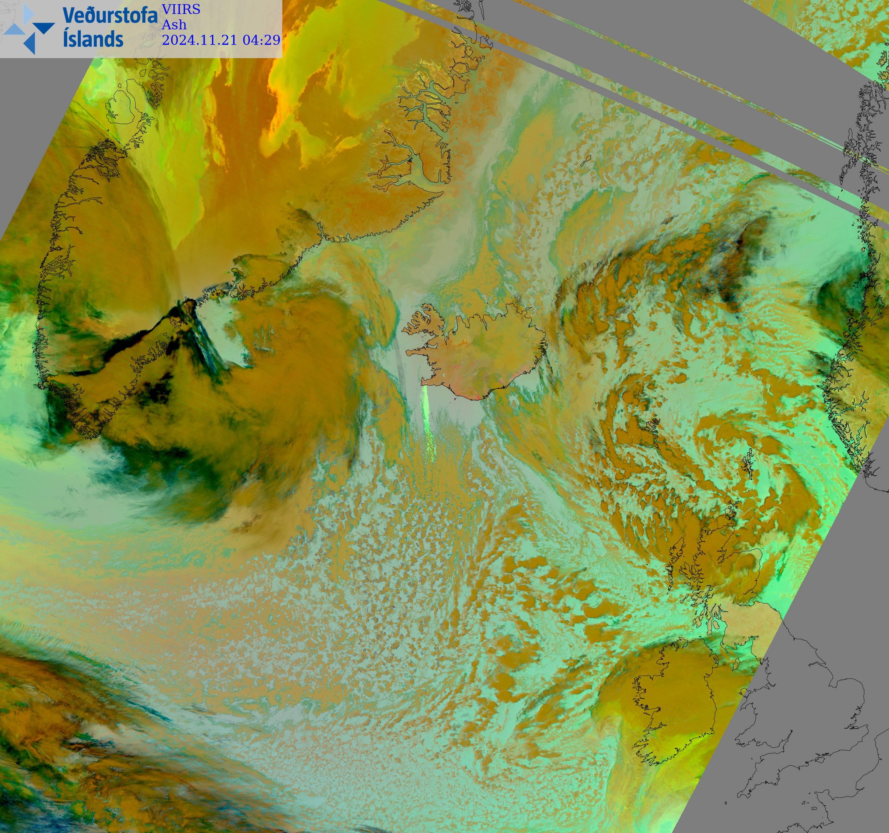
Satellite imagery shows the eruption plume drifting southward at 04:41 this morning, consisting primarily of SO2 gas. From the onset of the eruption until late at night, winds were northerly, shifting to easterly in the early morning hours today.
The Icelandic Meteorological Office (IMO) updated the hazard assessment last night (November 20), which is effective until 15:00 on November 22 unless conditions change. Hazard levels have been elevated in all zones except Zone 7. A very high hazard (purple) is in effect for Zone 3, where the eruption originates. Hazard levels for Zones 1, 4, and 6 have been raised to high (red).

Updated at 02:10
The activity in the eruption appears to have peaked. The fissure seems to have stopped expanding, and based on measurements from the Icelandic Meteorological Office, there are no indications that the activity will increase.
The length of the eruption fissure is estimated to be about 3 km. The lava flow is spreading both eastward and westward. At this point, the lava front is approximately 500 meters away from Grindavíkurvegur to the west.
This eruption is significantly smaller than the last eruption, which began on 22 August. The estimated lava flow rate at present is about 1,300 m³/s, compared to approximately 2,500 m³/s during the August eruption.
What stands out is that seismic activity did not start increasing in the weeks leading up to this eruption, as was observed in previous events. The amount of magma that had accumulated beneath Svartsengi was similar to the amount prior to the last eruption. However, the recent trend indicates that increasingly larger volumes of magma are required to trigger the next event. This suggests that the pattern observed in earlier eruptions may be changing.
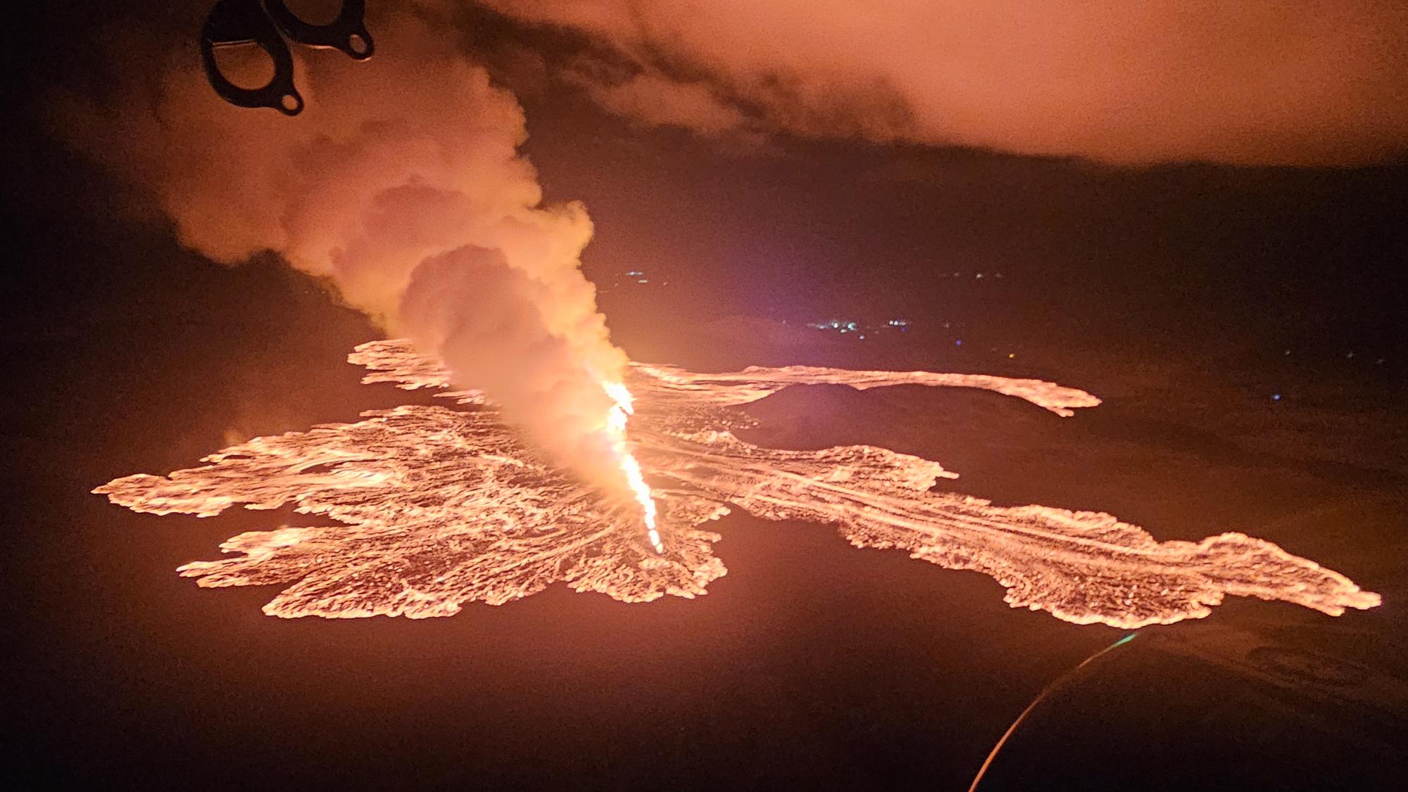
(Photo: Civil Protection/Björn Oddsson)
Updated at 00:10
A small earthquake swarm began at around 10:30 PM on 20 November. This was followed by pressure changes at 10:37 PM in boreholes operated by HS Orka. Both independent measurements were a clear sign of the onset of a magma intrusion.
At 11:14 PM on 20 November, a volcanic fissure opened between Stóra-Skógfell and Sýlingarfell. The fissure extended north-eastward.
Initial reports of lava-flow indicate that lava is moving westward, south of Stóra-Skógfell. No lava flow has been observed heading southwards towards Grindavík.
Strong northerly winds in the area are directing gas emissions southward over Grindavík.
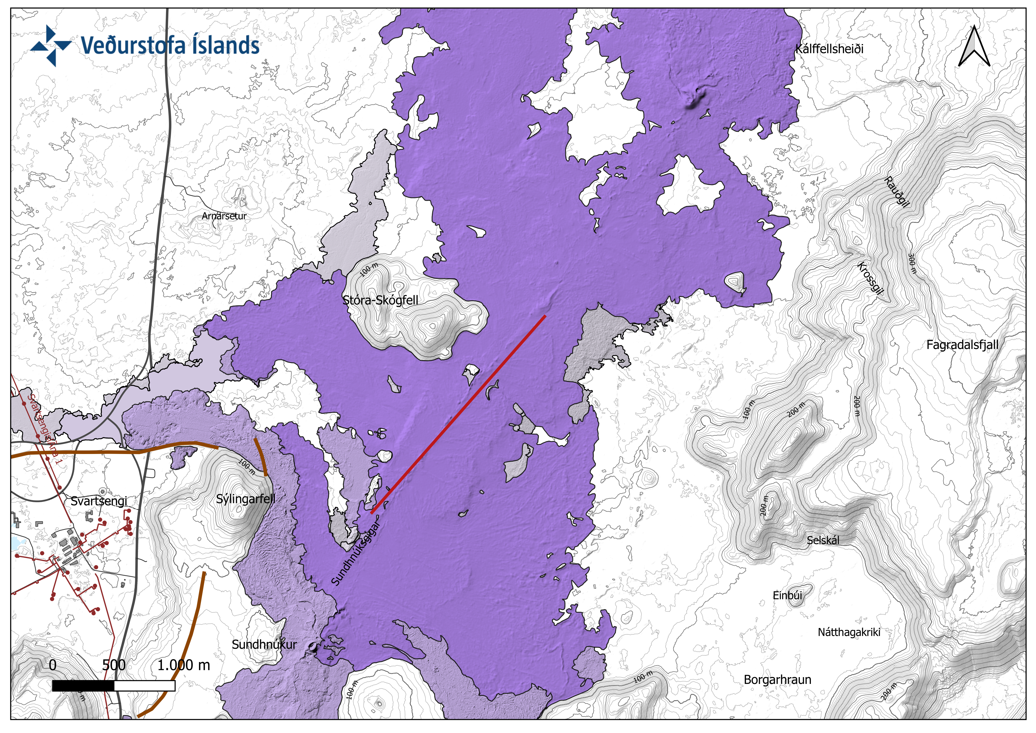
Map showing the estimated location of the eruptive fissure as of 11:40 PM on 20 November. The location is based on radar data from IMO's radar station at Keflavík Airport.

Funny Tee Collections - Laugh You *ss Off and Look Damn Google While doing...
teevibeusa.com/blogs/blog/funny-tee-collection-lau…