
 Photo Sept. 5 of the two craters. No activity is visible. (Photo: Public Safety/Björn Oddsson)
Uplift and Magma Accumulation Continue in Svartsengi
Updated 12. November at 17:45 UTC
Seismic activity along the Sundhnúkur crater row remains relatively low.
Land rise and magma accumulation beneath Svartsengi continue.
Based on the rate of magma inflow and the volume that has accumulated so far, the likelihood that an eruption will occur in November is considered to be low.
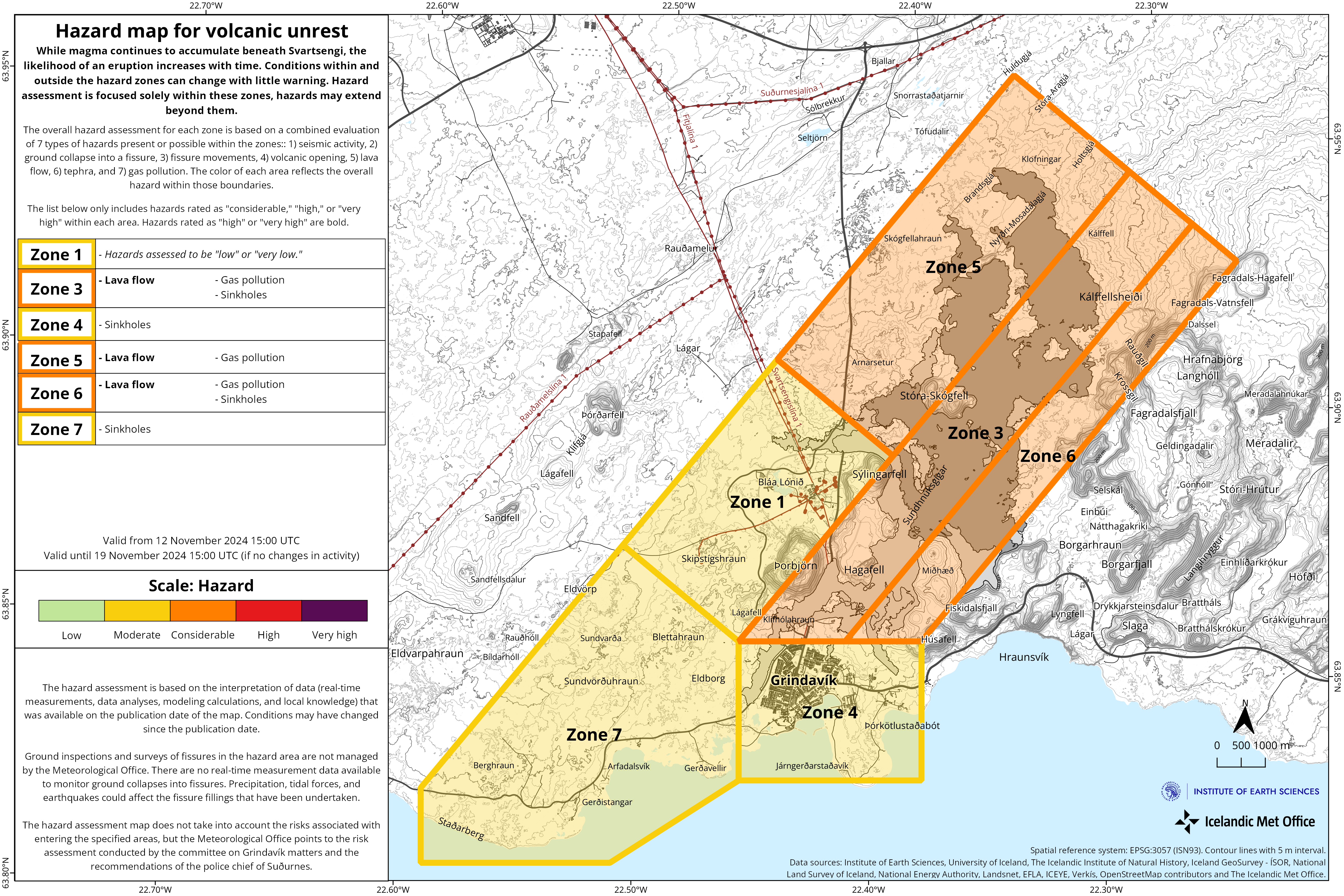
The hazard assessment remains unchanged.
Seismic activity along the Sundhnúkur crater row remains relatively low. Typically, a few earthquakes are recorded each day and are generally located between Stóra-Skógfell and Sýlingarfell. In recent days, however, weather conditions have decreased the sensitivity of the seismic monitoring system.
Ground uplift and magma accumulation under Svartsengi have continued at a rate similar to recent weeks. An estimation of the volume of magma that will likely be required to trigger a new intrusion or eruption has been calculated. The minimum volume required is estimated to be approximately 23 million cubic meters. If magma accumulation continues at a similar rate, this threshold could be reached by the end of November.
According to the interpretation of the latest data, and based on experience from previous events, it is unlikely that sufficient pressure will have built up to trigger an eruption in November. If the rate of uplift in Svartsengi changes, this assessment will be adjusted accordingly.
The Icelandic Meteorological Office has issued an updated hazard assessment, which remains unchanged from the previous one. The assessment is valid until November 19, unless circumstances change.
Leading up to the last two eruptions, seismic activity in the area northwest of Grindavík increased in the weeks before the eruptions began. This seismic activity is interpreted to indicate that pressure in the magma chamber is starting to build, suggesting the next event may be approaching.
Lessons from previous magma intrusions and eruptions provide insight into estimating how much additional magma must accumulate under Svartsengi to trigger the next event. The period with an increased likelihood of a magma intrusion, and potentially an eruption, is defined by lower and upper uncertainty thresholds. It is also important to observe how seismic activity increases in conjunction with magma accumulation.
If a significant increase in seismic activity is recorded when the magma volume under Svartsengi reaches the lower uncertainty threshold, the likelihood of a new magma intrusion and potential eruption increases. The likelihood will then gradually increase as more magma accumulates and seismic activity intensifies. It should be noted that the risk of an eruption could be high for several weeks before a magma intrusion and possible eruption begins.
Updated 8. November at 18:00 UTC
Low levels of seismic activity have been recorded around the Sundhnúkur crater row following the earthquake swarm that occurred early on Monday, November 4
The total volume of magma under Svartsengi is now approximately 80% of what had accumulated before the last eruption, which began on August 22
Additional webcams have been installed to better monitor eruption fissures and lava flow
In the early hours of Monday, November 4, a brief earthquake swarm was recorded at the Sundhnúkur crater row. Since then, seismic activity in the area has been low, with only five small earthquakes detected since the swarm ended. It is likely that strong winds in recent days have affected the earthquake detection system's ability to detect the smallest earthquakes in the region.
Ground uplift and magma accumulation are ongoing in Svartsengi. The total magma volume beneath Svartsengi is now about 80% of what had accumulated prior to the eruption that started on August 22. If the rate of magma accumulation remains steady, it may soon reach the level observed before the last dike intrusion and eruption onset. However, the Icelandic Meteorological Office expects that a greater volume of magma will need to accumulate beneath Svartsengi to trigger the next intrusion.
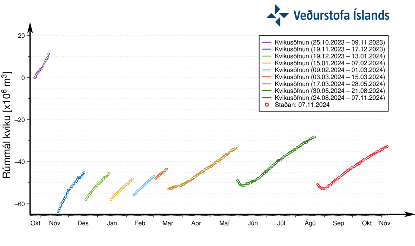
Graph showing the development of magma accumulation and the estimated total volume of magma in the reservoir beneath Svartsengi since October 25. The total volume of magma under Svartsengi is now approximately 80% of what had accumulated before the eruption that began on August 22.
The Icelandic Meteorological Office has installed two new webcams. The new cameras are located at the northern and southern ends of the region experiencing unrest, on Litla-Skógfell in the north and Húsafjall in the south. In addition, plans are underway to install two more webcams in the near future. These webcams should improve monitoring capabilities of eruptive vents and lava flows in the event of an eruption. as the total length of the Sundhnúkur crater row—where eruptive fissures are likely to open—is around 9 km.
Updated 4. November at 18:30 UTC
Between 2 and 3 a.m. last night, a minor earthquake swarm occurred between Sýlingarfell and Stóra-Skógfell. Over twenty earthquakes were recorded, around or below a magnitude 1.0, at depths of 3 to 6 km. The location of these earthquakes is very close to areas where earthquakes were observed at the beginning of magma intrusions along the Sundhnúkar crater row in the past year. The earthquake swarm was brief, with no further activity detected since 4 a.m. last night.
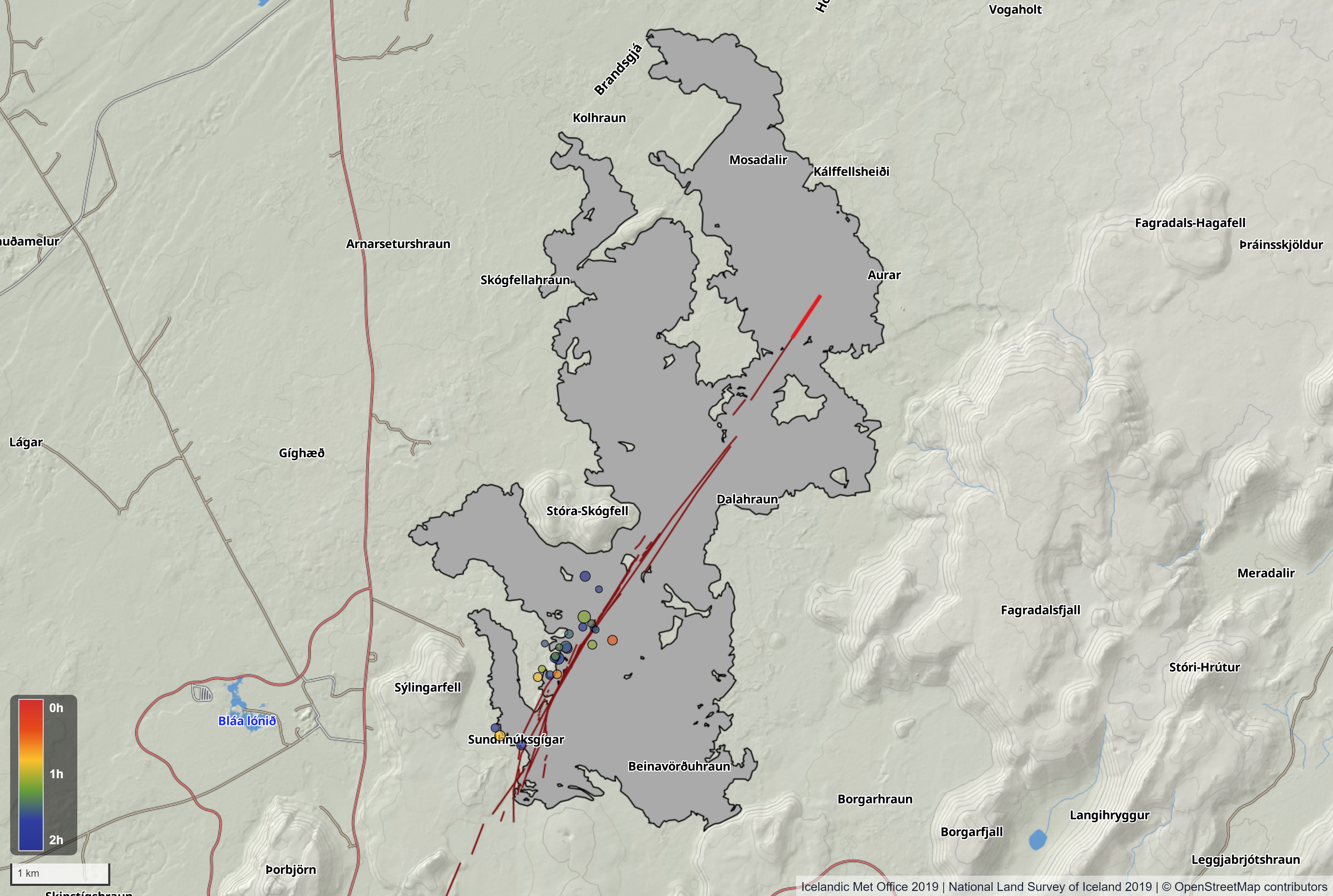
Map showing the location of earthquakes between 2 and 4 a.m. last night. Dark red lines mark the eruptive fissures on the Sundhnúkar crater row from December 2023 to August 2024. The brighter red line represents the section of the eruptive fissure that remained active during the last eruption. The gray area indicates the extent of the lava flow produced by the eruption from August 22 to September 5. The placement of the fissure and lava field is based on data from the Icelandic Institute of Natural History's imaging team and the National Land Survey of Iceland.
No signs of deformation were observed by the GPS stations or fiber optics, nor were there pressure changes in the HS Orka boreholes in Svartsengi. When magma traveled from Svartsengi to the Sundhnúkar crater row in the past, these monitoring devices have shown clear signs.
One possible explanation for the seismic activity last night is that magma migration started but was halted before any significant intrusion occurred. No signs of changes in magma accumulation under Svartsengi have appeared on the IMO's instruments following the earthquake swarm.
Following standard response protocols, the Icelandic Meteorological Office notified the Civil Protection Department about the earthquake swarm and informed them that experts were assessing whether a magma intrusion had begun. Since no other indicators of an intrusion were detected, it was decided that no further action would be taken overnight.

Funny Tee Collections - Laugh You *ss Off and Look Damn Google While doing...
teevibeusa.com/blogs/blog/funny-tee-collection-lau…