
 A Volcanic eruption started at Sundhnúks crater row 22 August. This photo is taken one hour after the eruption started and the eruption fracture is estimated approximately 4 km long. Photo: Björn Oddsson/Civil Protection.
No indication that magma accumulation has stopped
Updated 17. October at 16:00 UTC
Based on the current measurements, we estimate about 4-5 weeks until a new eruption will be considered likely
GPS measurements in Svartsengi area show that inflation continues at a similar rate
Warning immediately prior to an eruption can be short, even as short as only 30 minutes
Continue to be few earthquakes around the Sundhnúkar crater row
Hazard assessment unchanged
The progression of magma accumulation beneath and land uplift above Svartsengi has remained unchanged in recent weeks. GPS measurements in the Svartsengi area suggest that the land uplift continues at a steady rate. It slowed down slightly about 1-2 weeks ago but has not diminished further. While the rate of land uplift has diminished slightly, there is no indication that magma accumulation beneath Svartsengi has stopped.
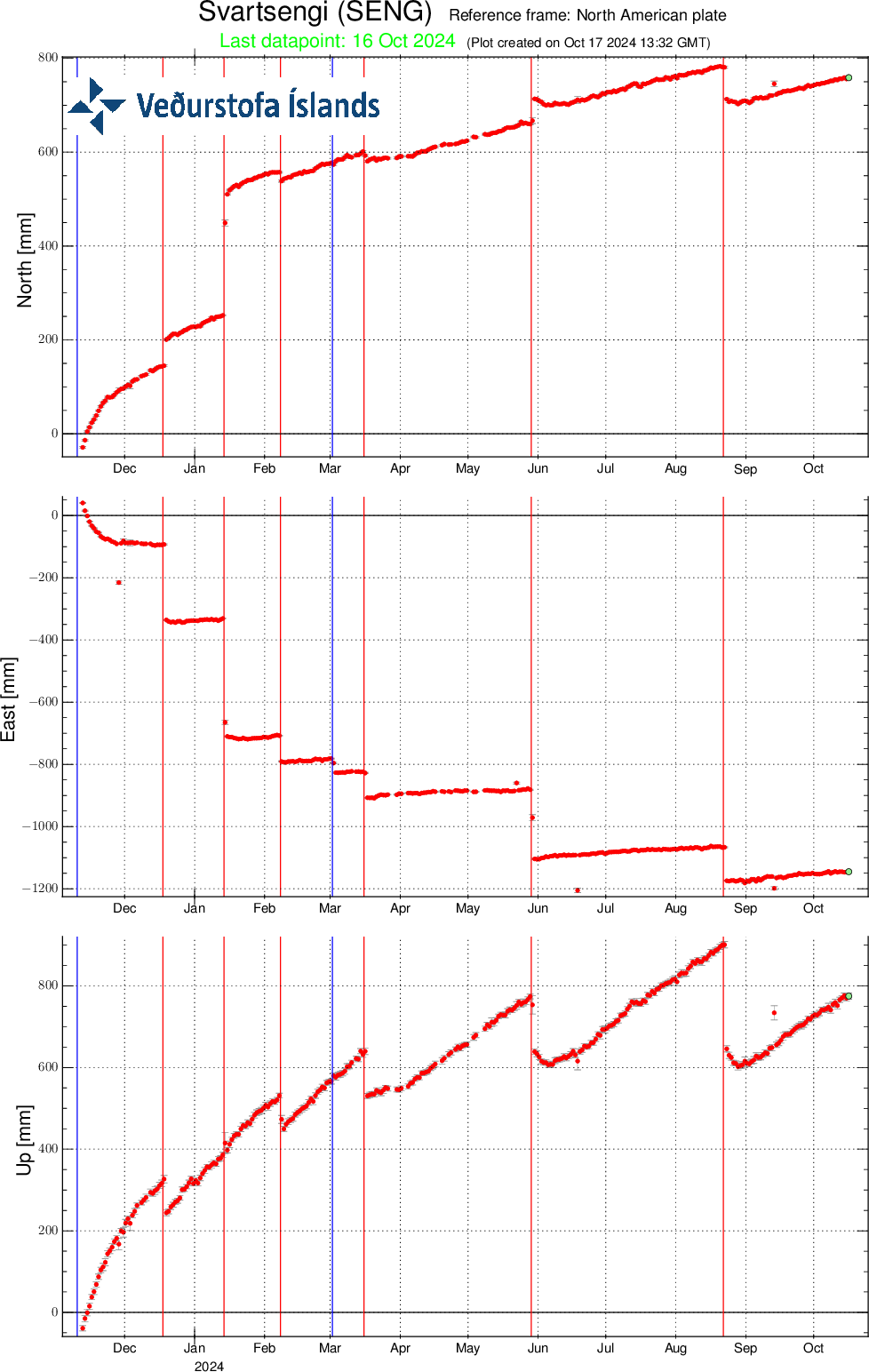 Ground movement at the GPS station SENG in Svartsengi since November 11, 2023 in the north, east, and vertical directions (top, middle, bottom). The bottom graph shows vertical movement in millimeters. Yesterday´s measurement (October 16) is shown with a green point. The red lines mark the start of the previous eruptions, which began on December 18, 2023, January 14, February 8, March 16, May 29 and August 22, 2024. The blue lines indicate dyke movements that did not result in an eruption on November 10, 2023 and March 2, 2024.
Experience of previous dyke movements and eruptions helps with estimating how much magma needs to accumulate beneath Svartsengi to trigger the next event. Models calculate that about 24 million m3 of magma left the magma accumulation zone beneath Svartsengi to erupt at the Sundhnúkur crater row in the last eruption that started August 22. There has been a trend that the same amount or more magma than left during the last event has needed to accumulate prior to each subsequent dyke movement or eruption.
If magma accumulation continues at a similar rate as now the most likely outcome is considered a dike propagation and possibly an eruption at the Sundhnúks crater row. At this point there still significant uncertainty in the possible timing of the next event. The magma accumulation will be monitored closely and efforts will be made to assess the time to the next event when more data will be available for analysis.
Warnings immediately prior to an eruption can be very short
When magma starts to move, the first signs are an increase in earthquakes, rapid changes in ground deformation and pressure changes in boreholes. The time between the first signal and when an eruption might start can be very short. There were only 30 minutes prior to the most recent eruption on August 22.
This assessment is based on the newest monitoring data from the Met Office and developments will continue to be closely monitored. There remains significant uncertainty about the timing of the next potential event and if the rate of magma accumulation changes this will affect the forecast.
Earthquakes around the Sundhnúkur crater row remain few but there continue to be several earthquakes per day for the past month. Earthquake activity west of Fagradalsfjall has diminished over the past few weeks.
The hazard assessment from the Met Office has been updated and remains unchanged. There remains the hazard of sinkholes in Area 4, Grindavík. The hazard assessment is valid until October 29 barring any developments.
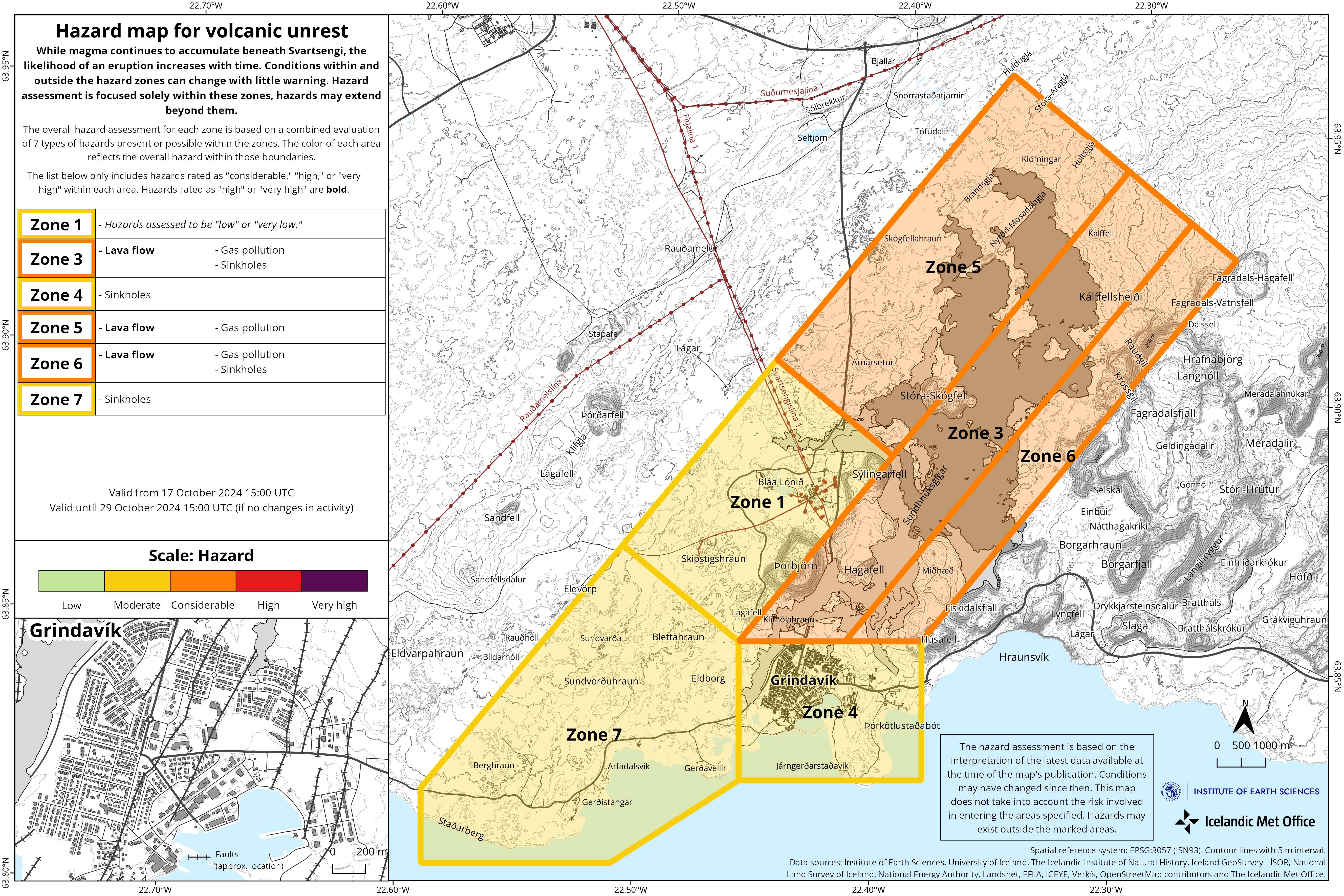
(Click on the map to make it larger)

Funny Tee Collections - Laugh You *ss Off and Look Damn Google While doing...
teevibeusa.com/blogs/blog/funny-tee-collection-lau…